Argeșelu geodata
Argeșelu (Arges) is a populated place; located in Romania in Europe/Bucharest (GMT+3) time zone. With population of 1,501 people, there are 3176 cities with bigger population in this country. Compared to other cities in Romania, 72.3% of cities are located further ↑North; 54.4% of cities are located further →East and 65.9% of cities have lower elevation than Argeșelu. Note1


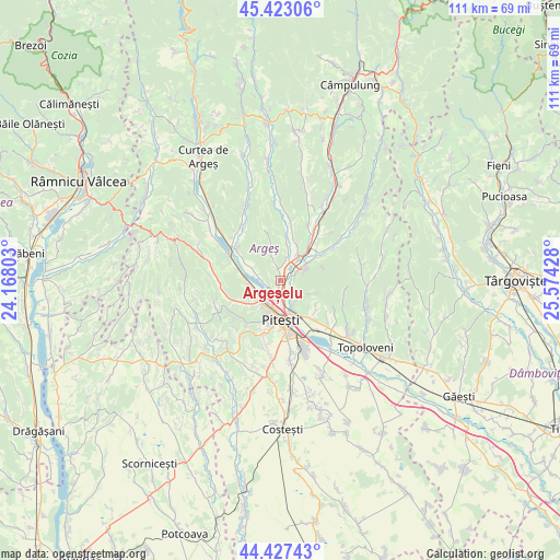
Argeșelu GPS coordinates[2]
44° 55' 38.64" North, 24° 52' 16.14" East
| Map corner | latitude | longitude |
|---|---|---|
| Upper-left | 45.42306°, | 24.16803° |
| Center: | 44.9274°, | 24.87115° |
| Lower-right: | 44.42743°, | 25.57428° |
| Map W x H: | 110.7×110.7 km | = 68.8×68.8mi |
| max Lat: | 48.23793° ⇑72.3% North |
| Argeșelu: | 44.9274° |
| min Lat: | ⇓27.7% South 43.65638° |
| min Long | Argeșelu | max Long |
| 20.31667° | 24.87115° | 29.65403° |
| W 45.6%⇐ | ⇒54.4% E |
Elevation
Elevation of Argeșelu is 295 m = 968 ft, and this is 40.1 m = 132 ft above average elevation for this country.
| Max E: |
1278 m = 4193 ft | 34.1% |
| Argeșelu | 295 m 968 ft | |
| Avg. | 254.9 m = 836 ft | |
Min E: |
-2 m = -7 ft | 65.9% |
See also: Romania elevation on elevation.city.
Geographical zone
Argeșelu is located in North temperate zone (between Tropic of Cancer and the Arctic Circle). Distance of this Northern Tropic circle is 2389.5 km =1484.8 mi to South.| Distance of | km | miles | from Argeșelu |
|---|---|---|---|
| North Pole | 5011.6 | 3114.1 | to North |
| Arctic Circle | 2405.7 | 1494.8 | to North |
| Tropic Cancer | 2389.5 | 1484.8 | to South |
| Equator | 4995.5 | 3104.1 | to South |


Nearby cities:
15 places around Argeșelu: (largest is in red/bold)
• Başcov
5.3 km =3.3 mi,  234°
234°
• Budeasa Mare
3.5 km =2.2 mi,  266°
266°
• Budeasa Mică
3 km =1.9 mi,  326°
326°
• Colibași
3.1 km =1.9 mi,  73°
73°
• Dobrogostea
6.9 km =4.3 mi, 271°
• Enculești
6.6 km =4.1 mi,  112°
112°
• Făgetu
4 km =2.5 mi,  126°
126°
• Glâmbocu
7.2 km =4.5 mi,  238°
238°
• Gălășești
7.4 km =4.6 mi,  295°
295°
• Miceşti
2.5 km =1.6 mi,  352°
352°
• Mioveni
6.6 km =4.1 mi,  57°
57°
• Mărăcineni
3.2 km =2 mi,  162°
162°
• Purcăreni
4.7 km =2.9 mi,  15°
15°
• Uiasca
6.1 km =3.8 mi,  217°
217°
• Valea Mare-Podgoria
5.4 km =3.4 mi,  149°
149°
Sources, notices
• [Note1] Compared only with cities in Romania existing in our database
• [Src1] Map data: © OpenStreetMap contributors (CC-BY-SA)
• [Src2] Other city data from geonames.org with taken over terms of usage.
• [Src3] Geographical zone / Annual Mean Temperature by Robert A. Rohde @ Wikipedia
