Bărbuceni geodata
Bărbuceni (Vâlcea) is a populated place; located in Romania in Europe/Bucharest (GMT+3) time zone. With population of 571 people, there are 6419 cities with bigger population in this country. Compared to other cities in Romania, 78.5% of cities are located further ↑North; 65.1% of cities are located further →East and 58.9% of cities have higher elevation than Bărbuceni. Note1


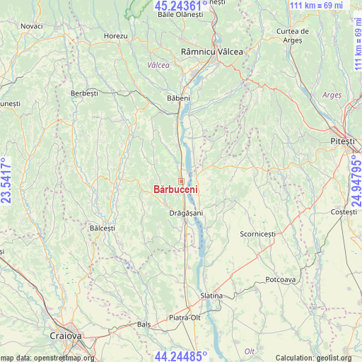
Bărbuceni GPS coordinates[2]
44° 44' 47.004" North, 24° 14' 41.352" East
| Map corner | latitude | longitude |
|---|---|---|
| Upper-left | 45.24361°, | 23.5417° |
| Center: | 44.74639°, | 24.24482° |
| Lower-right: | 44.24485°, | 24.94795° |
| Map W x H: | 111.1×111.1 km | = 69×69mi |
| max Lat: | 48.23793° ⇑78.5% North |
| Bărbuceni: | 44.74639° |
| min Lat: | ⇓21.5% South 43.65638° |
| min Long | Bărbuceni | max Long |
| 20.31667° | 24.24482° | 29.65403° |
| W 34.9%⇐ | ⇒65.1% E |
Elevation
Elevation of Bărbuceni is 170 m = 558 ft, and this is 84.9 m = 279 ft below average elevation for this country.
| Max E: |
1278 m = 4193 ft | 58.9% |
| Avg. | 254.9 m = 836 ft | |
| Bărbuceni | 170 m = 558 ft | |
Min E: |
-2 m = -7 ft | 41.1% |
See also: Romania elevation on elevation.city.
Geographical zone
Bărbuceni is located in North temperate zone (between Tropic of Cancer and the Arctic Circle). Distance of this Northern Tropic circle is 2369.4 km =1472.3 mi to South.| Distance of | km | miles | from Bărbuceni |
|---|---|---|---|
| North Pole | 5031.7 | 3126.6 | to North |
| Arctic Circle | 2425.8 | 1507.3 | to North |
| Tropic Cancer | 2369.4 | 1472.3 | to South |
| Equator | 4975.3 | 3091.5 | to South |


Nearby cities:
15 places around Bărbuceni: (largest is in red/bold)
• Amărăşti
7.8 km =4.8 mi,  286°
286°
• Creţeni
8.5 km =5.3 mi,  214°
214°
• Călina
5 km =3.1 mi,  171°
171°
• Geamăna
7.9 km =4.9 mi,  30°
30°
• Izvoru
6 km =3.7 mi,  251°
251°
• Mitrofani
3.2 km =2 mi,  241°
241°
• Mrenești
6.3 km =3.9 mi,  229°
229°
• Nemoiu
6.2 km =3.9 mi,  268°
268°
• Orleşti
6.4 km =4 mi,  339°
339°
• Procopoaia
3.7 km =2.3 mi,  347°
347°
• Prundeni
2.3 km =1.4 mi,  130°
130°
• Valea lui Alb
7 km =4.3 mi, 128°
• Verdea
6.3 km =3.9 mi,  192°
192°
• Vultureşti
5.9 km =3.7 mi,  104°
104°
• Zăvideni
0.8 km =0.5 mi,  356°
356°
Sources, notices
• [Note1] Compared only with cities in Romania existing in our database
• [Src1] Map data: © OpenStreetMap contributors (CC-BY-SA)
• [Src2] Other city data from geonames.org with taken over terms of usage.
• [Src3] Geographical zone / Annual Mean Temperature by Robert A. Rohde @ Wikipedia
