Băluşeni geodata
Băluşeni (Botoşani) is a seat of a second-order administrative division; located in Romania in Europe/Bucharest (GMT+3) time zone. With population of 5,017 people, there are 777 cities with bigger population in this country. Compared to other cities in Romania, 94.3% of cities are located further ↓South; 78.7% of cities are located further ←West and 79.6% of cities have higher elevation than Băluşeni. Note1


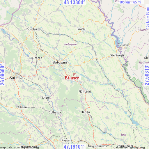
Băluşeni GPS coordinates[2]
47° 40' 0.012" North, 26° 48' 0" East
| Map corner | latitude | longitude |
|---|---|---|
| Upper-left | 48.13804°, | 26.09688° |
| Center: | 47.66667°, | 26.8° |
| Lower-right: | 47.19101°, | 27.50313° |
| Map W x H: | 105.3×105.3 km | = 65.4×65.4mi |
| max Lat: | 48.23793° ⇑5.7% North |
| Băluşeni: | 47.66667° |
| min Lat: | ⇓94.3% South 43.65638° |
| min Long | Băluşeni | max Long |
| 20.31667° | 26.8° | 29.65403° |
| W 78.7%⇐ | ⇒21.3% E |
Elevation
Elevation of Băluşeni is 96 m = 315 ft, and this is 158.9 m = 521 ft below average elevation for this country.
| Max E: |
1278 m = 4193 ft | 79.6% |
| Avg. | 254.9 m = 836 ft | |
| Băluşeni | 96 m = 315 ft | |
Min E: |
-2 m = -7 ft | 20.4% |
See also: Romania elevation on elevation.city.
Geographical zone
Băluşeni is located in North temperate zone (between Tropic of Cancer and the Arctic Circle). Distance of this North polar circle is 2101.1 km =1305.6 mi to North.| Distance of | km | miles | from Băluşeni |
|---|---|---|---|
| North Pole | 4707 | 2924.8 | to North |
| Arctic Circle | 2101.1 | 1305.6 | to North |
| Tropic Cancer | 2694.1 | 1674 | to South |
| Equator | 5300 | 3293.3 | to South |


Nearby cities:
15 places around Băluşeni: (largest is in red/bold)
• Blândeşti
6.2 km =3.9 mi,  53°
53°
• Cerbu
8.5 km =5.3 mi,  130°
130°
• Cerchejeni
6.8 km =4.2 mi,  65°
65°
• Copălău
6.1 km =3.8 mi,  155°
155°
• Cotu
8.9 km =5.5 mi,  148°
148°
• Coșula
4.8 km =3 mi,  199°
199°
• Cristeşti
6.2 km =3.9 mi,  233°
233°
• Draxini
2.2 km =1.4 mi, 146°
• Pădureni
6 km =3.7 mi, 200°
• Schit-Orășeni
8.8 km =5.5 mi,  249°
249°
• Stăuceni
6.7 km =4.2 mi,  326°
326°
• Sulița
8.9 km =5.5 mi,  101°
101°
• Tocileni
5 km =3.1 mi,  348°
348°
• Zăicești
6.2 km =3.9 mi,  294°
294°
• Șupitca
6.5 km =4 mi,  190°
190°
Sources, notices
• [Note1] Compared only with cities in Romania existing in our database
• [Src1] Map data: © OpenStreetMap contributors (CC-BY-SA)
• [Src2] Other city data from geonames.org with taken over terms of usage.
• [Src3] Geographical zone / Annual Mean Temperature by Robert A. Rohde @ Wikipedia
