Băicoi geodata
Băicoi (Prahova) is a seat of a second-order administrative division; located in Romania in Europe/Bucharest (GMT+3) time zone. With population of 19,869 people, there are 106 cities with bigger population in this country. Compared to other cities in Romania, 68.5% of cities are located further ↑North; 60.1% of cities are located further ←West and 69% of cities have lower elevation than Băicoi. Note1


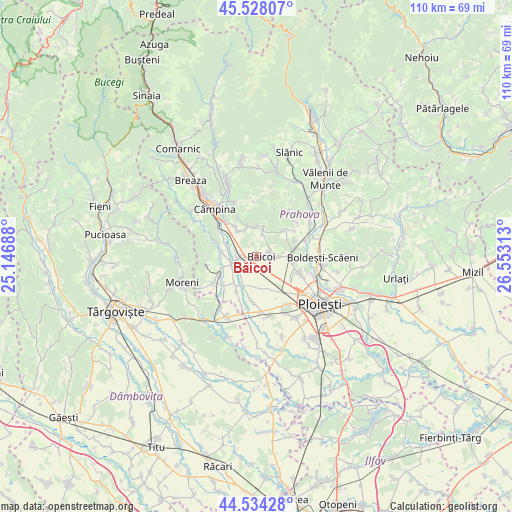
Băicoi GPS coordinates[2]
45° 1' 59.988" North, 25° 51' 0" East
| Map corner | latitude | longitude |
|---|---|---|
| Upper-left | 45.52807°, | 25.14688° |
| Center: | 45.03333°, | 25.85° |
| Lower-right: | 44.53428°, | 26.55313° |
| Map W x H: | 110.5×110.5 km | = 68.7×68.7mi |
| max Lat: | 48.23793° ⇑68.5% North |
| Băicoi: | 45.03333° |
| min Lat: | ⇓31.5% South 43.65638° |
| min Long | Băicoi | max Long |
| 20.31667° | 25.85° | 29.65403° |
| W 60.1%⇐ | ⇒39.9% E |
Elevation
Elevation of Băicoi is 312 m = 1024 ft, and this is 57.1 m = 187 ft above average elevation for this country.
| Max E: |
1278 m = 4193 ft | 31% |
| Băicoi | 312 m 1024 ft | |
| Avg. | 254.9 m = 836 ft | |
Min E: |
-2 m = -7 ft | 69% |
See also: Romania elevation on elevation.city.
Geographical zone
Băicoi is located in North temperate zone (between Tropic of Cancer and the Arctic Circle). Distance of this North polar circle is 2393.9 km =1487.5 mi to North.| Distance of | km | miles | from Băicoi |
|---|---|---|---|
| North Pole | 4999.8 | 3106.7 | to North |
| Arctic Circle | 2393.9 | 1487.5 | to North |
| Tropic Cancer | 2401.3 | 1492.1 | to South |
| Equator | 5007.2 | 3111.3 | to South |


Nearby cities:
15 places around Băicoi: (largest is in red/bold)
• Bordenii Mari
6.4 km =4 mi,  13°
13°
• Bordenii Mici
5.1 km =3.2 mi, 14°
• Cătina
5.8 km =3.6 mi,  243°
243°
• Dâmbu
3.3 km =2.1 mi,  66°
66°
• Floreşti
5.6 km =3.5 mi,  289°
289°
• Liliești
2.8 km =1.7 mi,  87°
87°
• Lunca Prahovei
6.3 km =3.9 mi,  283°
283°
• Mislea
7.3 km =4.5 mi,  344°
344°
• Nedelea
7.3 km =4.5 mi,  201°
201°
• Novăcești
5.6 km =3.5 mi,  262°
262°
• Schela
1 km =0.6 mi,  353°
353°
• Scorţeni
7.4 km =4.6 mi,  0°
0°
• Tufeni
2.8 km =1.7 mi, 343°
• Urleta
7.5 km =4.7 mi,  323°
323°
• Țintea
4.3 km =2.7 mi, 88°
Sources, notices
• [Note1] Compared only with cities in Romania existing in our database
• [Src1] Map data: © OpenStreetMap contributors (CC-BY-SA)
• [Src2] Other city data from geonames.org with taken over terms of usage.
• [Src3] Geographical zone / Annual Mean Temperature by Robert A. Rohde @ Wikipedia
