Floreşti geodata
Floreşti (Prahova) is a seat of a second-order administrative division; located in Romania in Europe/Bucharest (GMT+3) time zone. With population of 7,507 people, there are 354 cities with bigger population in this country. Compared to other cities in Romania, 67.8% of cities are located further ↑North; 58.8% of cities are located further ←West and 71.9% of cities have lower elevation than Floreşti. Note1


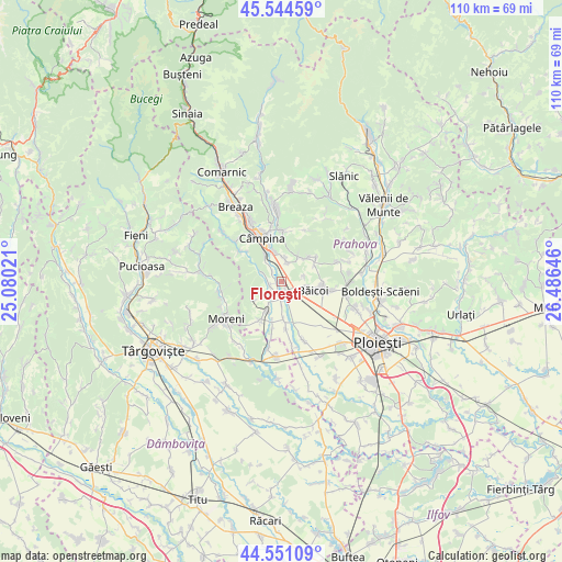
Floreşti GPS coordinates[2]
45° 3' 0" North, 25° 46' 59.988" East
| Map corner | latitude | longitude |
|---|---|---|
| Upper-left | 45.54459°, | 25.08021° |
| Center: | 45.05°, | 25.78333° |
| Lower-right: | 44.55109°, | 26.48646° |
| Map W x H: | 110.5×110.5 km | = 68.7×68.7mi |
| max Lat: | 48.23793° ⇑67.8% North |
| Floreşti: | 45.05° |
| min Lat: | ⇓32.2% South 43.65638° |
| min Long | Floreşti | max Long |
| 20.31667° | 25.78333° | 29.65403° |
| W 58.8%⇐ | ⇒41.2% E |
Elevation
Elevation of Floreşti is 333 m = 1093 ft, and this is 78.1 m = 256 ft above average elevation for this country.
| Max E: |
1278 m = 4193 ft | 28.1% |
| Floreşti | 333 m 1093 ft | |
| Avg. | 254.9 m = 836 ft | |
Min E: |
-2 m = -7 ft | 71.9% |
See also: Romania elevation on elevation.city.
Geographical zone
Floreşti is located in North temperate zone (between Tropic of Cancer and the Arctic Circle). Distance of this North polar circle is 2392.1 km =1486.4 mi to North.| Distance of | km | miles | from Floreşti |
|---|---|---|---|
| North Pole | 4998 | 3105.6 | to North |
| Arctic Circle | 2392.1 | 1486.4 | to North |
| Tropic Cancer | 2403.2 | 1493.3 | to South |
| Equator | 5009.1 | 3112.5 | to South |


Nearby cities:
15 places around Floreşti: (largest is in red/bold)
• Bobolia
5.8 km =3.6 mi,  326°
326°
• Bordenii Mici
7.2 km =4.5 mi,  64°
64°
• Băicoi
5.6 km =3.5 mi,  109°
109°
• Băneşti
5.7 km =3.5 mi,  346°
346°
• Cocorăștii Caplii
2.5 km =1.6 mi,  317°
317°
• Cătina
4.5 km =2.8 mi,  179°
179°
• Filipeştii de Pădure
6.1 km =3.8 mi,  205°
205°
• Filipeştii de Târg
7.4 km =4.6 mi, 180°
• Lunca Prahovei
1 km =0.6 mi,  250°
250°
• Mislea
6.1 km =3.8 mi,  31°
31°
• Măgureni
4.3 km =2.7 mi,  295°
295°
• Novăcești
2.6 km =1.6 mi,  188°
188°
• Schela
5.2 km =3.2 mi,  99°
99°
• Tufeni
4.5 km =2.8 mi,  78°
78°
• Urleta
4.2 km =2.6 mi,  10°
10°
Sources, notices
• [Note1] Compared only with cities in Romania existing in our database
• [Src1] Map data: © OpenStreetMap contributors (CC-BY-SA)
• [Src2] Other city data from geonames.org with taken over terms of usage.
• [Src3] Geographical zone / Annual Mean Temperature by Robert A. Rohde @ Wikipedia
