Baciu geodata
Baciu (Cluj) is a seat of a second-order administrative division; located in Romania in Europe/Bucharest (GMT+3) time zone. With population of 8,046 people, there are 308 cities with bigger population in this country. Compared to other cities in Romania, 74.1% of cities are located further ↓South; 76.8% of cities are located further →East and 80.2% of cities have lower elevation than Baciu. Note1


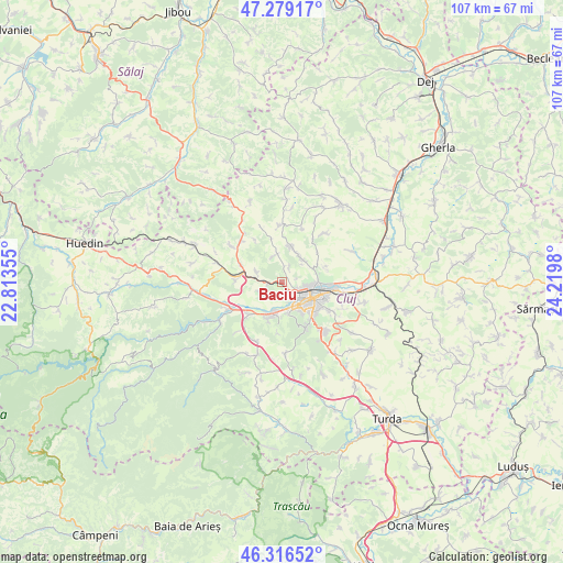
Baciu GPS coordinates[2]
46° 48' 0" North, 23° 31' 0.012" East
| Map corner | latitude | longitude |
|---|---|---|
| Upper-left | 47.27917°, | 22.81355° |
| Center: | 46.8°, | 23.51667° |
| Lower-right: | 46.31652°, | 24.2198° |
| Map W x H: | 107×107 km | = 66.5×66.5mi |
| max Lat: | 48.23793° ⇑25.9% North |
| Baciu: | 46.8° |
| min Lat: | ⇓74.1% South 43.65638° |
| min Long | Baciu | max Long |
| 20.31667° | 23.51667° | 29.65403° |
| W 23.2%⇐ | ⇒76.8% E |
Elevation
Elevation of Baciu is 395 m = 1296 ft, and this is 140.1 m = 460 ft above average elevation for this country.
| Max E: |
1278 m = 4193 ft | 19.8% |
| Baciu | 395 m 1296 ft | |
| Avg. | 254.9 m = 836 ft | |
Min E: |
-2 m = -7 ft | 80.2% |
See also: Romania elevation on elevation.city.
Geographical zone
Baciu is located in North temperate zone (between Tropic of Cancer and the Arctic Circle). Distance of this North polar circle is 2197.5 km =1365.5 mi to North.| Distance of | km | miles | from Baciu |
|---|---|---|---|
| North Pole | 4803.4 | 2984.7 | to North |
| Arctic Circle | 2197.5 | 1365.5 | to North |
| Tropic Cancer | 2597.8 | 1614.2 | to South |
| Equator | 5203.7 | 3233.4 | to South |


Nearby cities:
15 places around Baciu: (largest is in red/bold)
• Chinteni
7.5 km =4.7 mi,  9°
9°
• Cluj-Napoca
7.3 km =4.5 mi,  120°
120°
• Corușu
5.2 km =3.2 mi,  346°
346°
• Feleacu
12 km =7.5 mi,  140°
140°
• Floreşti
6.3 km =3.9 mi,  196°
196°
• Luna de Sus
8.8 km =5.5 mi,  224°
224°
• Mera
5.1 km =3.2 mi,  289°
289°
• Popești
3.1 km =1.9 mi,  27°
27°
• Suceagu
4.3 km =2.7 mi,  246°
246°
• Sânmărtin
11.8 km =7.3 mi,  18°
18°
• Sânpaul
12 km =7.5 mi,  320°
320°
• Vechea
10.2 km =6.3 mi, 349°
• Viștea
8.7 km =5.4 mi,  271°
271°
• Vlaha
12.4 km =7.7 mi, 202°
• Șardu
11.7 km =7.3 mi,  305°
305°
Sources, notices
• [Note1] Compared only with cities in Romania existing in our database
• [Src1] Map data: © OpenStreetMap contributors (CC-BY-SA)
• [Src2] Other city data from geonames.org with taken over terms of usage.
• [Src3] Geographical zone / Annual Mean Temperature by Robert A. Rohde @ Wikipedia
