Avrămești geodata
Avrămești (Vâlcea) is a populated place; located in Romania in Europe/Bucharest (GMT+3) time zone. With population of 593 people, there are 6250 cities with bigger population in this country. Compared to other cities in Romania, 74.7% of cities are located further ↑North; 66.5% of cities are located further →East and 61.5% of cities have lower elevation than Avrămești. Note1


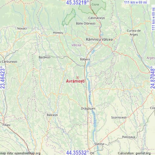
Avrămești GPS coordinates[2]
44° 51' 21.276" North, 24° 10' 2.46" East
| Map corner | latitude | longitude |
|---|---|---|
| Upper-left | 45.35219°, | 23.46423° |
| Center: | 44.85591°, | 24.16735° |
| Lower-right: | 44.35532°, | 24.87048° |
| Map W x H: | 110.8×110.8 km | = 68.8×68.8mi |
| max Lat: | 48.23793° ⇑74.7% North |
| Avrămești: | 44.85591° |
| min Lat: | ⇓25.3% South 43.65638° |
| min Long | Avrămești | max Long |
| 20.31667° | 24.16735° | 29.65403° |
| W 33.5%⇐ | ⇒66.5% E |
Elevation
Elevation of Avrămești is 272 m = 892 ft, and this is 17.1 m = 56 ft above average elevation for this country.
| Max E: |
1278 m = 4193 ft | 38.5% |
| Avrămești | 272 m 892 ft | |
| Avg. | 254.9 m = 836 ft | |
Min E: |
-2 m = -7 ft | 61.5% |
See also: Romania elevation on elevation.city.
Geographical zone
Avrămești is located in North temperate zone (between Tropic of Cancer and the Arctic Circle). Distance of this Northern Tropic circle is 2381.6 km =1479.9 mi to South.| Distance of | km | miles | from Avrămești |
|---|---|---|---|
| North Pole | 5019.6 | 3119 | to North |
| Arctic Circle | 2413.7 | 1499.8 | to North |
| Tropic Cancer | 2381.6 | 1479.9 | to South |
| Equator | 4987.5 | 3099.1 | to South |


Nearby cities:
15 places around Avrămești: (largest is in red/bold)
• Amărăşti
10 km =6.2 mi,  187°
187°
• Batârăşti
4.6 km =2.9 mi,  197°
197°
• Blejani
4.4 km =2.7 mi,  139°
139°
• Cioboți
9.7 km =6 mi,  93°
93°
• Cueni
7.9 km =4.9 mi,  301°
301°
• Glăvile
4.6 km =2.9 mi, 197°
• Ioneşti
5.2 km =3.2 mi,  97°
97°
• Lădeşti
9.7 km =6 mi,  288°
288°
• Marcea
7.6 km =4.7 mi,  44°
44°
• Olteanca
6.8 km =4.2 mi,  221°
221°
• Orleşti
7.3 km =4.5 mi,  147°
147°
• Pesceana
3.3 km =2.1 mi,  335°
335°
• Roeşti
9.5 km =5.9 mi,  315°
315°
• Scundu
3.6 km =2.2 mi,  134°
134°
• Şirineasa
9 km =5.6 mi,  16°
16°
Sources, notices
• [Note1] Compared only with cities in Romania existing in our database
• [Src1] Map data: © OpenStreetMap contributors (CC-BY-SA)
• [Src2] Other city data from geonames.org with taken over terms of usage.
• [Src3] Geographical zone / Annual Mean Temperature by Robert A. Rohde @ Wikipedia
