Aluniş geodata
Aluniş (Cluj) is a seat of a second-order administrative division; located in Romania in Europe/Bucharest (GMT+3) time zone. With population of 1,370 people, there are 3395 cities with bigger population in this country. Compared to other cities in Romania, 79.7% of cities are located further ↓South; 73.4% of cities are located further →East and 69.7% of cities have lower elevation than Aluniş. Note1


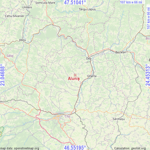
Aluniş GPS coordinates[2]
47° 1' 59.988" North, 23° 45' 0" East
| Map corner | latitude | longitude |
|---|---|---|
| Upper-left | 47.51041°, | 23.04688° |
| Center: | 47.03333°, | 23.75° |
| Lower-right: | 46.55195°, | 24.45313° |
| Map W x H: | 106.6×106.6 km | = 66.2×66.2mi |
| max Lat: | 48.23793° ⇑20.3% North |
| Aluniş: | 47.03333° |
| min Lat: | ⇓79.7% South 43.65638° |
| min Long | Aluniş | max Long |
| 20.31667° | 23.75° | 29.65403° |
| W 26.6%⇐ | ⇒73.4% E |
Elevation
Elevation of Aluniş is 318 m = 1043 ft, and this is 63.1 m = 207 ft above average elevation for this country.
| Max E: |
1278 m = 4193 ft | 30.3% |
| Aluniş | 318 m 1043 ft | |
| Avg. | 254.9 m = 836 ft | |
Min E: |
-2 m = -7 ft | 69.7% |
See also: Romania elevation on elevation.city.
Geographical zone
Aluniş is located in North temperate zone (between Tropic of Cancer and the Arctic Circle). Distance of this North polar circle is 2171.6 km =1349.4 mi to North.| Distance of | km | miles | from Aluniş |
|---|---|---|---|
| North Pole | 4777.4 | 2968.5 | to North |
| Arctic Circle | 2171.6 | 1349.4 | to North |
| Tropic Cancer | 2623.7 | 1630.3 | to South |
| Equator | 5229.6 | 3249.5 | to South |


Nearby cities:
15 places around Aluniş: (largest is in red/bold)
• Bunești
10.3 km =6.4 mi,  74°
74°
• Corneşti
5.1 km =3.2 mi,  270°
270°
• Cubleşu Someşan
9 km =5.6 mi,  281°
281°
• Dăbâca
8.4 km =5.2 mi,  228°
228°
• Fundătura
8.9 km =5.5 mi,  164°
164°
• Gherla
12.6 km =7.8 mi,  90°
90°
• Ghirolt
2.7 km =1.7 mi,  76°
76°
• Iclod
6.7 km =4.2 mi,  145°
145°
• Jichişu de Jos
10 km =6.2 mi,  22°
22°
• Livada
8 km =5 mi,  115°
115°
• Luna de Jos
10.8 km =6.7 mi,  175°
175°
• Nima
10.2 km =6.3 mi,  61°
61°
• Ocna Dejului
12.4 km =7.7 mi,  42°
42°
• Orman
5.6 km =3.5 mi, 73°
• Pintic
6 km =3.7 mi,  34°
34°
Sources, notices
• [Note1] Compared only with cities in Romania existing in our database
• [Src1] Map data: © OpenStreetMap contributors (CC-BY-SA)
• [Src2] Other city data from geonames.org with taken over terms of usage.
• [Src3] Geographical zone / Annual Mean Temperature by Robert A. Rohde @ Wikipedia
