Fundătura geodata
Fundătura (Cluj) is a populated place; located in Romania in Europe/Bucharest (GMT+3) time zone. With population of 716 people, there are 5480 cities with bigger population in this country. Compared to other cities in Romania, 78% of cities are located further ↓South; 72.9% of cities are located further →East and 62.3% of cities have lower elevation than Fundătura. Note1


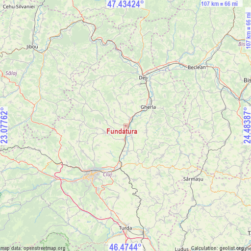
Fundătura GPS coordinates[2]
46° 57' 23.292" North, 23° 46' 50.664" East
| Map corner | latitude | longitude |
|---|---|---|
| Upper-left | 47.43424°, | 23.07762° |
| Center: | 46.95647°, | 23.78074° |
| Lower-right: | 46.4744°, | 24.48387° |
| Map W x H: | 106.7×106.7 km | = 66.3×66.3mi |
| max Lat: | 48.23793° ⇑22% North |
| Fundătura: | 46.95647° |
| min Lat: | ⇓78% South 43.65638° |
| min Long | Fundătura | max Long |
| 20.31667° | 23.78074° | 29.65403° |
| W 27.1%⇐ | ⇒72.9% E |
Elevation
Elevation of Fundătura is 276 m = 906 ft, and this is 21.1 m = 69 ft above average elevation for this country.
| Max E: |
1278 m = 4193 ft | 37.7% |
| Fundătura | 276 m 906 ft | |
| Avg. | 254.9 m = 836 ft | |
Min E: |
-2 m = -7 ft | 62.3% |
See also: Romania elevation on elevation.city.
Geographical zone
Fundătura is located in North temperate zone (between Tropic of Cancer and the Arctic Circle). Distance of this North polar circle is 2180.1 km =1354.7 mi to North.| Distance of | km | miles | from Fundătura |
|---|---|---|---|
| North Pole | 4786 | 2973.9 | to North |
| Arctic Circle | 2180.1 | 1354.7 | to North |
| Tropic Cancer | 2615.2 | 1625 | to South |
| Equator | 5221.1 | 3244.2 | to South |


Nearby cities:
15 places around Fundătura: (largest is in red/bold)
• Aluniş
8.9 km =5.5 mi,  344°
344°
• Bonțida
5.2 km =3.2 mi,  150°
150°
• Borşa
9 km =5.6 mi,  253°
253°
• Corneşti
11.3 km =7 mi,  319°
319°
• Dăbâca
9.2 km =5.7 mi,  289°
289°
• Gherla
13.4 km =8.3 mi,  50°
50°
• Ghirolt
9.2 km =5.7 mi,  1°
1°
• Iclod
3.3 km =2.1 mi,  26°
26°
• Jucu de Mijloc
12.7 km =7.9 mi,  182°
182°
• Livada
7.1 km =4.4 mi,  44°
44°
• Luna de Jos
2.7 km =1.7 mi,  215°
215°
• Orman
10.6 km =6.6 mi,  16°
16°
• Răscruci
5.7 km =3.5 mi,  189°
189°
• Sic
8.2 km =5.1 mi,  108°
108°
• Vișea
13.2 km =8.2 mi, 147°
Sources, notices
• [Note1] Compared only with cities in Romania existing in our database
• [Src1] Map data: © OpenStreetMap contributors (CC-BY-SA)
• [Src2] Other city data from geonames.org with taken over terms of usage.
• [Src3] Geographical zone / Annual Mean Temperature by Robert A. Rohde @ Wikipedia
