Alba geodata
Alba (Botoşani) is a populated place; located in Romania in Europe/Bucharest (GMT+3) time zone. With population of 1,599 people, there are 3049 cities with bigger population in this country. Compared to other cities in Romania, 99.8% of cities are located further ↓South; 72.2% of cities are located further ←West and 65.4% of cities have higher elevation than Alba. Note1


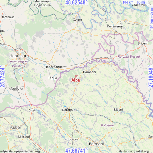
Alba GPS coordinates[2]
48° 9' 30.924" North, 26° 28' 38.496" East
| Map corner | latitude | longitude |
|---|---|---|
| Upper-left | 48.62548°, | 25.77424° |
| Center: | 48.15859°, | 26.47736° |
| Lower-right: | 47.68741°, | 27.18049° |
| Map W x H: | 104.3×104.3 km | = 64.8×64.8mi |
| max Lat: | 48.23793° ⇑0.2% North |
| Alba: | 48.15859° |
| min Lat: | ⇓99.8% South 43.65638° |
| min Long | Alba | max Long |
| 20.31667° | 26.47736° | 29.65403° |
| W 72.2%⇐ | ⇒27.8% E |
Elevation
Elevation of Alba is 145 m = 476 ft, and this is 109.9 m = 361 ft below average elevation for this country.
| Max E: |
1278 m = 4193 ft | 65.4% |
| Avg. | 254.9 m = 836 ft | |
| Alba | 145 m = 476 ft | |
Min E: |
-2 m = -7 ft | 34.6% |
See also: Romania elevation on elevation.city.
Geographical zone
Alba is located in North temperate zone (between Tropic of Cancer and the Arctic Circle). Distance of this North polar circle is 2046.4 km =1271.6 mi to North.| Distance of | km | miles | from Alba |
|---|---|---|---|
| North Pole | 4652.3 | 2890.8 | to North |
| Arctic Circle | 2046.4 | 1271.6 | to North |
| Tropic Cancer | 2748.8 | 1708 | to South |
| Equator | 5354.7 | 3327.3 | to South |


Nearby cities:
15 places around Alba: (largest is in red/bold)
• Arborea
12.3 km =7.6 mi,  165°
165°
• Bajura
6.6 km =4.1 mi,  44°
44°
• Baranca
4.2 km =2.6 mi,  1°
1°
• Baranca
12.3 km =7.6 mi,  257°
257°
• Conceşti
5.5 km =3.4 mi,  80°
80°
• Cristineşti
9.5 km =5.9 mi,  226°
226°
• Darabani
8.3 km =5.2 mi,  70°
70°
• Dragalina
11.5 km =7.1 mi,  188°
188°
• Hudeşti
1.9 km =1.2 mi,  119°
119°
• Ibăneşti
13.1 km =8.1 mi,  218°
218°
• Lișna
5.7 km =3.5 mi,  180°
180°
• Mlenăuți
3.7 km =2.3 mi, 165°
• Oroftiana
9.8 km =6.1 mi,  282°
282°
• Smârdan
8.8 km =5.5 mi, 183°
• Suharău
5.3 km =3.3 mi,  238°
238°
Sources, notices
• [Note1] Compared only with cities in Romania existing in our database
• [Src1] Map data: © OpenStreetMap contributors (CC-BY-SA)
• [Src2] Other city data from geonames.org with taken over terms of usage.
• [Src3] Geographical zone / Annual Mean Temperature by Robert A. Rohde @ Wikipedia
