Jarebice geodata
Jarebice (Central Serbia) is a populated locality; located in Serbia in Europe/Belgrade (GMT+2) time zone. With population of 1,549 people, there are 254 cities with bigger population in this country. Compared to other cities in Serbia, 68.7% of cities are located further ↑North; 90.5% of cities are located further →East and 73% of cities have lower elevation than Jarebice. Note1


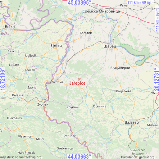
Jarebice GPS coordinates[2]
44° 32' 23.82" North, 19° 25' 27.048" East
| Map corner | latitude | longitude |
|---|---|---|
| Upper-left | 45.03895°, | 18.72106° |
| Center: | 44.53995°, | 19.42418° |
| Lower-right: | 44.03663°, | 20.12731° |
| Map W x H: | 111.4×111.4 km | = 69.2×69.2mi |
| max Lat: | 46.1° ⇑68.7% North |
| Jarebice: | 44.53995° |
| min Lat: | ⇓31.3% South 42.25846° |
| min Long | Jarebice | max Long |
| 18.9276° | 19.42418° | 22.77556° |
| W 9.5%⇐ | ⇒90.5% E |
Elevation
Elevation of Jarebice is 179 m = 587 ft, and this is 2.6 m = 9 ft above average elevation for this country.
| Max E: |
1421 m = 4662 ft | 27% |
| Jarebice | 179 m 587 ft | |
| Avg. | 176.4 m = 579 ft | |
Min E: |
49 m = 161 ft | 73% |
See also: Serbia elevation on elevation.city.
Geographical zone
Jarebice is located in North temperate zone (between Tropic of Cancer and the Arctic Circle). Distance of this Northern Tropic circle is 2346.5 km =1458 mi to South.| Distance of | km | miles | from Jarebice |
|---|---|---|---|
| North Pole | 5054.7 | 3140.8 | to North |
| Arctic Circle | 2448.8 | 1521.6 | to North |
| Tropic Cancer | 2346.5 | 1458 | to South |
| Equator | 4952.4 | 3077.3 | to South |


Nearby cities:
15 places around Jarebice: (largest is in red/bold)
• Bukor
12.7 km =7.9 mi,  113°
113°
• Donja Badanja
5.6 km =3.5 mi,  133°
133°
• Donji Dobrić
10.9 km =6.8 mi,  317°
317°
• Gornje Nedeljice
7.2 km =4.5 mi,  248°
248°
• Gornji Dobrić
10.3 km =6.4 mi,  297°
297°
• Grnčara
9.9 km =6.2 mi,  266°
266°
• Jadranska Lešnica
8.6 km =5.3 mi, 318°
• Joševa
5.4 km =3.4 mi,  347°
347°
• Kozjak
12.3 km =7.6 mi, 295°
• Krivaja
13.3 km =8.3 mi,  85°
85°
• Lipnički Šor
13.3 km =8.3 mi,  289°
289°
• Rumska
13.6 km =8.5 mi,  74°
74°
• Tekeriš
8.6 km =5.3 mi,  77°
77°
• Tršić
13.6 km =8.5 mi, 248°
• Čokešina
12.9 km =8 mi, 347°
Sources, notices
• [Note1] Compared only with cities in Serbia existing in our database
• [Src1] Map data: © OpenStreetMap contributors (CC-BY-SA)
• [Src2] Other city data from geonames.org with taken over terms of usage.
• [Src3] Geographical zone / Annual Mean Temperature by Robert A. Rohde @ Wikipedia
