Vranje geodata
Vranje (Central Serbia) is a seat of a second-order administrative division; located in Serbia in Europe/Belgrade (GMT+2) time zone. With population of 56,199 people, there are 16 cities with bigger population in this country. Compared to other cities in Serbia, 96.1% of cities are located further ↑North; 93.9% of cities are located further ←West and 93.9% of cities have lower elevation than Vranje. Note1


Vranje GPS coordinates[2]
42° 33' 5.004" North, 21° 54' 1.008" East
| Map corner | latitude | longitude |
|---|---|---|
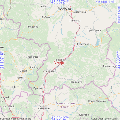
| Upper-left | 43.06721°, | 21.19716° |
| Center: | 42.55139°, | 21.90028° |
| Lower-right: | 42.03127°, | 22.60341° |
| Map W x H: | 115.2×115.2 km | = 71.6×71.6mi |
| max Lat: | 46.1° ⇑96.1% North |
| Vranje: | 42.55139° |
| min Lat: | ⇓3.9% South 42.25846° |
| min Long | Vranje | max Long |
| 18.9276° | 21.90028° | 22.77556° |
| W 93.9%⇐ | ⇒6.1% E |
Elevation
Elevation of Vranje is 468 m = 1535 ft, and this is 291.6 m = 957 ft above average elevation for this country.
| Max E: |
1421 m = 4662 ft | 6.1% |
| Vranje | 468 m 1535 ft | |
| Avg. | 176.4 m = 579 ft | |
Min E: |
49 m = 161 ft | 93.9% |
See also: Vranje elevation on elevation.city.
Geographical zone
Vranje is located in North temperate zone (between Tropic of Cancer and the Arctic Circle). Distance of this Northern Tropic circle is 2125.4 km =1320.7 mi to South.| Distance of | km | miles | from Vranje |
|---|---|---|---|
| North Pole | 5275.8 | 3278.2 | to North |
| Arctic Circle | 2669.9 | 1659 | to North |
| Tropic Cancer | 2125.4 | 1320.7 | to South |
| Equator | 4731.3 | 2939.9 | to South |


Nearby cities:
15 places around Vranje: (largest is in red/bold)
• Biljača
25.1 km =15.6 mi,  209°
209°
• Bujanovac
15 km =9.3 mi,  226°
226°
• Kriva Feja
22.5 km =14 mi,  87°
87°
• Lagja e Korbajve
22.4 km =13.9 mi,  215°
215°
• Lagja e Poshtme
22.9 km =14.2 mi, 217°
• Lagja e Shimshirve
23.1 km =14.4 mi, 214°
• Lagja e Ternovcalive
22.1 km =13.7 mi, 215°
• Rajince
25.5 km =15.8 mi, 221°
• Samoljica
22.9 km =14.2 mi, 215°
• Spančevac
21.3 km =13.2 mi,  189°
189°
• Sumulicë
22.8 km =14.2 mi, 216°
• Surdulica
27 km =16.8 mi,  55°
55°
• Trgovište
25.6 km =15.9 mi,  144°
144°
• Vladičin Han
21.9 km =13.6 mi,  37°
37°
• Vranjska Banja
7.5 km =4.7 mi, 86°
Sources, notices
• [Note1] Compared only with cities in Serbia existing in our database
• [Src1] Map data: © OpenStreetMap contributors (CC-BY-SA)
• [Src2] Other city data from geonames.org with taken over terms of usage.
• [Src3] Geographical zone / Annual Mean Temperature by Robert A. Rohde @ Wikipedia
