Trgovište geodata
Trgovište (Central Serbia) is a seat of a third-order administrative division; located in Serbia in Europe/Belgrade (GMT+2) time zone. In our database, there are 365 cities with bigger population. Compared to other cities in Serbia, 98.6% of cities are located further ↑North; 95.9% of cities are located further ←West and 96.6% of cities have lower elevation than Trgovište. Note1


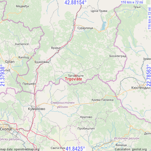
Trgovište GPS coordinates[2]
42° 21' 51.012" North, 22° 4' 57" East
| Map corner | latitude | longitude |
|---|---|---|
| Upper-left | 42.88154°, | 21.37938° |
| Center: | 42.36417°, | 22.0825° |
| Lower-right: | 41.8425°, | 22.78563° |
| Map W x H: | 115.5×115.5 km | = 71.8×71.8mi |
| max Lat: | 46.1° ⇑98.6% North |
| Trgovište: | 42.36417° |
| min Lat: | ⇓1.4% South 42.25846° |
| min Long | Trgovište | max Long |
| 18.9276° | 22.0825° | 22.77556° |
| W 95.9%⇐ | ⇒4.1% E |
Elevation
Elevation of Trgovište is 623 m = 2044 ft, and this is 446.6 m = 1465 ft above average elevation for this country.
| Max E: |
1421 m = 4662 ft | 3.4% |
| Trgovište | 623 m 2044 ft | |
| Avg. | 176.4 m = 579 ft | |
Min E: |
49 m = 161 ft | 96.6% |
See also: Serbia elevation on elevation.city.
Geographical zone
Trgovište is located in North temperate zone (between Tropic of Cancer and the Arctic Circle). Distance of this Northern Tropic circle is 2104.5 km =1307.7 mi to South.| Distance of | km | miles | from Trgovište |
|---|---|---|---|
| North Pole | 5296.6 | 3291.2 | to North |
| Arctic Circle | 2690.7 | 1671.9 | to North |
| Tropic Cancer | 2104.5 | 1307.7 | to South |
| Equator | 4710.5 | 2927 | to South |


Nearby cities:
15 places around Trgovište: (largest is in red/bold)
• Biljača
27.5 km =17.1 mi,  267°
267°
• Bujanovac
28 km =17.4 mi,  292°
292°
• Buštranje
27.2 km =16.9 mi,  262°
262°
• Kriva Feja
23 km =14.3 mi,  19°
19°
• Lagja e Korbajve
28 km =17.4 mi,  275°
275°
• Lagja e Poshtme
29.1 km =18.1 mi, 275°
• Lagja e Shimshirve
28.2 km =17.5 mi, 273°
• Lagja e Ternovcalive
28 km =17.4 mi, 275°
• Radovnica
14.3 km =8.9 mi,  57°
57°
• Samoljica
28.5 km =17.7 mi, 274°
• Spančevac
18.6 km =11.6 mi, 269°
• Sumulicë
28.7 km =17.8 mi, 275°
• Vranje
25.6 km =15.9 mi,  324°
324°
• Vranjska Banja
22.5 km =14 mi,  340°
340°
• Žujince
31.7 km =19.7 mi, 260°
Sources, notices
• [Note1] Compared only with cities in Serbia existing in our database
• [Src1] Map data: © OpenStreetMap contributors (CC-BY-SA)
• [Src2] Other city data from geonames.org with taken over terms of usage.
• [Src3] Geographical zone / Annual Mean Temperature by Robert A. Rohde @ Wikipedia
