Pokrovka geodata
Pokrovka (Primorskiy (Maritime) Kray) is a populated place; located in Russia in Asia/Vladivostok (GMT+10) time zone. With population of 10,614 people, there are 1429 cities with bigger population in this country. Compared to other cities in Russia, 92% of cities are located further ↑North; 94.7% of cities are located further ←West and 85.1% of cities have higher elevation than Pokrovka. Note1


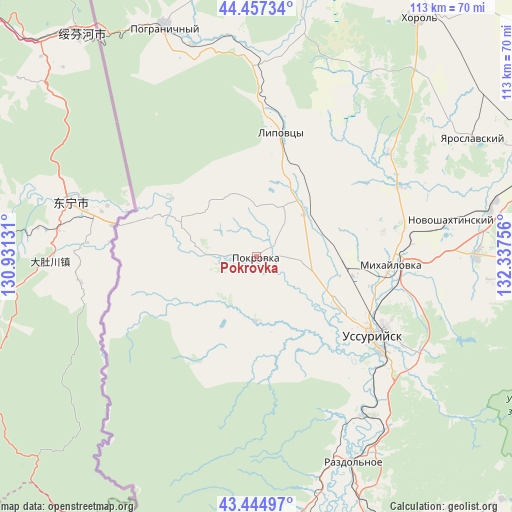
Pokrovka GPS coordinates[2]
43° 57' 11.916" North, 131° 38' 3.948" East
| Map corner | latitude | longitude |
|---|---|---|
| Upper-left | 44.45734°, | 130.93131° |
| Center: | 43.95331°, | 131.63443° |
| Lower-right: | 43.44497°, | 132.33756° |
| Map W x H: | 112.6×112.6 km | = 70×70mi |
| max Lat: | 73.50819° ⇑92% North |
| Pokrovka: | 43.95331° |
| min Lat: | ⇓8% South 41.28413° |
| min Long | Pokrovka | max Long |
| -179.12198° | 131.63443° | 179.35046° |
| W 94.7%⇐ | ⇒5.3% E |
Elevation
Elevation of Pokrovka is 47 m = 154 ft, and this is 155.6 m = 510 ft below average elevation for this country.
| Max E: |
2518 m = 8261 ft | 85.1% |
| Avg. | 202.6 m = 665 ft | |
| Pokrovka | 47 m = 154 ft | |
Min E: |
-28 m = -92 ft | 14.9% |
See also: Russia elevation on elevation.city.
Geographical zone
Pokrovka is located in North temperate zone (between Tropic of Cancer and the Arctic Circle). Distance of this Northern Tropic circle is 2281.2 km =1417.5 mi to South.| Distance of | km | miles | from Pokrovka |
|---|---|---|---|
| North Pole | 5119.9 | 3181.4 | to North |
| Arctic Circle | 2514 | 1562.1 | to North |
| Tropic Cancer | 2281.2 | 1417.5 | to South |
| Equator | 4887.1 | 3036.7 | to South |


Nearby cities:
15 places around Pokrovka: (largest is in red/bold)
• Blagodatnoye
54.9 km =34.1 mi,  41°
41°
• Grigor’yevka
36.9 km =22.9 mi,  51°
51°
• Kiparisovo
57.7 km =35.9 mi,  156°
156°
• Kiparisovo
61 km =37.9 mi, 156°
• Lipovtsy
28.4 km =17.6 mi,  14°
14°
• Mikhaylovka
30.1 km =18.7 mi,  94°
94°
• Nezhino
56.4 km =35 mi,  168°
168°
• Novonikol’sk
21.3 km =13.2 mi,  120°
120°
• Novoshakhtinskiy
43.3 km =26.9 mi,  79°
79°
• Pogranichnyy
54.7 km =34 mi,  338°
338°
• Razdol’noye
50.7 km =31.5 mi, 155°
• Sergeyevka
42.8 km =26.6 mi,  2°
2°
• Ussuriysk
30 km =18.6 mi, 123°
• Vozdvizhenka
25.8 km =16 mi,  104°
104°
• Yaroslavskiy
54.1 km =33.6 mi,  61°
61°
Sources, notices
• [Note1] Compared only with cities in Russia existing in our database
• [Src1] Map data: © OpenStreetMap contributors (CC-BY-SA)
• [Src2] Other city data from geonames.org with taken over terms of usage.
• [Src3] Geographical zone / Annual Mean Temperature by Robert A. Rohde @ Wikipedia
