Uglezavodsk geodata
Uglezavodsk (Sakhalin Oblast) is a populated place; located in Russia in Asia/Sakhalin (GMT+11) time zone. With population of 1,610 people, there are 4332 cities with bigger population in this country. Compared to other cities in Russia, 81.5% of cities are located further ↑North; 98.4% of cities are located further ←West and 89.2% of cities have higher elevation than Uglezavodsk. Note1


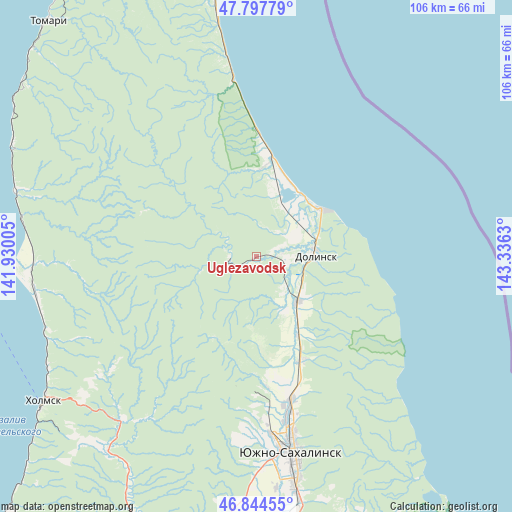
Uglezavodsk GPS coordinates[2]
47° 19' 23.952" North, 142° 37' 59.412" East
| Map corner | latitude | longitude |
|---|---|---|
| Upper-left | 47.79779°, | 141.93005° |
| Center: | 47.32332°, | 142.63317° |
| Lower-right: | 46.84455°, | 143.3363° |
| Map W x H: | 106×106 km | = 65.9×65.9mi |
| max Lat: | 73.50819° ⇑81.5% North |
| Uglezavodsk: | 47.32332° |
| min Lat: | ⇓18.5% South 41.28413° |
| min Long | Uglezavodsk | max Long |
| -179.12198° | 142.63317° | 179.35046° |
| W 98.4%⇐ | ⇒1.6% E |
Elevation
Elevation of Uglezavodsk is 31 m = 102 ft, and this is 171.6 m = 563 ft below average elevation for this country.
| Max E: |
2518 m = 8261 ft | 89.2% |
| Avg. | 202.6 m = 665 ft | |
| Uglezavodsk | 31 m = 102 ft | |
Min E: |
-28 m = -92 ft | 10.8% |
See also: Russia elevation on elevation.city.
Geographical zone
Uglezavodsk is located in North temperate zone (between Tropic of Cancer and the Arctic Circle). Distance of this North polar circle is 2139.3 km =1329.3 mi to North.| Distance of | km | miles | from Uglezavodsk |
|---|---|---|---|
| North Pole | 4745.2 | 2948.5 | to North |
| Arctic Circle | 2139.3 | 1329.3 | to North |
| Tropic Cancer | 2655.9 | 1650.3 | to South |
| Equator | 5261.9 | 3269.6 | to South |


Nearby cities:
15 places around Uglezavodsk: (largest is in red/bold)
• Aniva
68.1 km =42.3 mi,  186°
186°
• Bykov
5.4 km =3.4 mi,  267°
267°
• Chekhov
50.4 km =31.3 mi,  286°
286°
• Dolinsk
12.1 km =7.5 mi,  86°
86°
• Kholmsk
53.7 km =33.4 mi,  235°
235°
• Korsakov
77.4 km =48.1 mi,  171°
171°
• Nevel’sk
92.7 km =57.6 mi,  219°
219°
• Pravda
63.9 km =39.7 mi,  228°
228°
• Sinegorsk
18.9 km =11.7 mi,  207°
207°
• Sokol
12.5 km =7.8 mi,  134°
134°
• Tomari
64.7 km =40.2 mi,  319°
319°
• Troitskoye
44.3 km =27.5 mi,  178°
178°
• Vzmor’ye
59.1 km =36.7 mi,  351°
351°
• Yablochnyy
47.5 km =29.5 mi,  246°
246°
• Yuzhno-Sakhalinsk
41.8 km =26 mi, 169°
Sources, notices
• [Note1] Compared only with cities in Russia existing in our database
• [Src1] Map data: © OpenStreetMap contributors (CC-BY-SA)
• [Src2] Other city data from geonames.org with taken over terms of usage.
• [Src3] Geographical zone / Annual Mean Temperature by Robert A. Rohde @ Wikipedia
