Severo-Kuril’sk geodata
Severo-Kuril’sk (Sakhalin Oblast) is a populated place; located in Russia in Asia/Magadan (GMT+11) time zone. With population of 2,422 people, there are 3985 cities with bigger population in this country. Compared to other cities in Russia, 76.1% of cities are located further ↑North; 99.5% of cities are located further ←West and 96.4% of cities have higher elevation than Severo-Kuril’sk. Note1


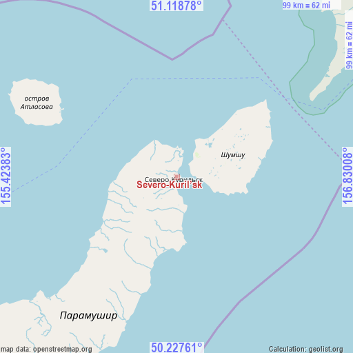
Severo-Kuril’sk GPS coordinates[2]
50° 40' 31.116" North, 156° 7' 37.02" East
| Map corner | latitude | longitude |
|---|---|---|
| Upper-left | 51.11878°, | 155.42383° |
| Center: | 50.67531°, | 156.12695° |
| Lower-right: | 50.22761°, | 156.83008° |
| Map W x H: | 99.1×99.1 km | = 61.6×61.6mi |
| max Lat: | 73.50819° ⇑76.1% North |
| Severo-Kuril’sk: | 50.67531° |
| min Lat: | ⇓23.9% South 41.28413° |
| min Long | Severo-Kuril’ | max Long |
| -179.12198° | 156.12695° | 179.35046° |
| W 99.5%⇐ | ⇒0.5% E |
Elevation
Elevation of Severo-Kuril’sk is 9 m = 30 ft, and this is 193.6 m = 635 ft below average elevation for this country.
| Max E: |
2518 m = 8261 ft | 96.4% |
| Avg. | 202.6 m = 665 ft | |
| Severo-Kuril’sk | 9 m = 30 ft | |
Min E: |
-28 m = -92 ft | 3.6% |
See also: Russia elevation on elevation.city.
Geographical zone
Severo-Kuril’sk is located in North temperate zone (between Tropic of Cancer and the Arctic Circle). Distance of this North polar circle is 1766.6 km =1097.7 mi to North.| Distance of | km | miles | from Severo-Kuril’sk |
|---|---|---|---|
| North Pole | 4372.5 | 2716.9 | to North |
| Arctic Circle | 1766.6 | 1097.7 | to North |
| Tropic Cancer | 3028.6 | 1881.9 | to South |
| Equator | 5634.6 | 3501.2 | to South |


Nearby cities:
5 places around Severo-Kuril’sk: (largest is in red/bold)
• Ozernovskiy
94.9 km =59 mi,  15°
15°
• Paratunka
293.4 km =182.3 mi,  29°
29°
• Petropavlovsk-Kamchatsky
315.3 km =195.9 mi, 33°
• Vilyuchinsk
295.7 km =183.7 mi, 31°
• Yelizovo
319.4 km =198.5 mi, 28°
Sources, notices
• [Note1] Compared only with cities in Russia existing in our database
• [Src1] Map data: © OpenStreetMap contributors (CC-BY-SA)
• [Src2] Other city data from geonames.org with taken over terms of usage.
• [Src3] Geographical zone / Annual Mean Temperature by Robert A. Rohde @ Wikipedia
