Gornozavodsk geodata
Gornozavodsk (Sakhalin Oblast) is a populated place; located in Russia in Asia/Sakhalin (GMT+11) time zone. With population of 5,579 people, there are 2408 cities with bigger population in this country. Compared to other cities in Russia, 82.9% of cities are located further ↑North; 98% of cities are located further ←West and 95.5% of cities have higher elevation than Gornozavodsk. Note1


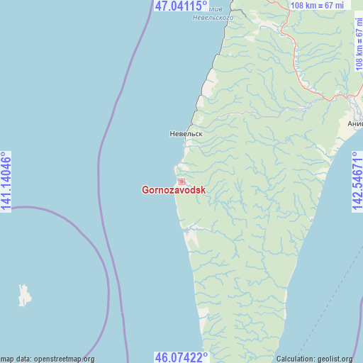
Gornozavodsk GPS coordinates[2]
46° 33' 35.424" North, 141° 50' 36.888" East
| Map corner | latitude | longitude |
|---|---|---|
| Upper-left | 47.04115°, | 141.14046° |
| Center: | 46.55984°, | 141.84358° |
| Lower-right: | 46.07422°, | 142.54671° |
| Map W x H: | 107.5×107.5 km | = 66.8×66.8mi |
| max Lat: | 73.50819° ⇑82.9% North |
| Gornozavodsk: | 46.55984° |
| min Lat: | ⇓17.1% South 41.28413° |
| min Long | Gornozavodsk | max Long |
| -179.12198° | 141.84358° | 179.35046° |
| W 98%⇐ | ⇒2% E |
Elevation
Elevation of Gornozavodsk is 11 m = 36 ft, and this is 191.6 m = 629 ft below average elevation for this country.
| Max E: |
2518 m = 8261 ft | 95.5% |
| Avg. | 202.6 m = 665 ft | |
| Gornozavodsk | 11 m = 36 ft | |
Min E: |
-28 m = -92 ft | 4.5% |
See also: Russia elevation on elevation.city.
Geographical zone
Gornozavodsk is located in North temperate zone (between Tropic of Cancer and the Arctic Circle). Distance of this North polar circle is 2224.2 km =1382.1 mi to North.| Distance of | km | miles | from Gornozavodsk |
|---|---|---|---|
| North Pole | 4830.1 | 3001.3 | to North |
| Arctic Circle | 2224.2 | 1382.1 | to North |
| Tropic Cancer | 2571 | 1597.5 | to South |
| Equator | 5177 | 3216.8 | to South |


Nearby cities:
15 places around Gornozavodsk: (largest is in red/bold)
• Aniva
55.1 km =34.2 mi,  71°
71°
• Bykov
100.7 km =62.6 mi,  32°
32°
• Chekhov
99.6 km =61.9 mi,  6°
6°
• Dolinsk
111.9 km =69.5 mi,  40°
40°
• Kholmsk
56.4 km =35 mi,  16°
16°
• Korsakov
71.8 km =44.6 mi,  83°
83°
• Nevel’sk
13.3 km =8.3 mi,  4°
4°
• Pravda
44 km =27.3 mi, 16°
• Shebunino
14.5 km =9 mi,  175°
175°
• Sinegorsk
85.2 km =52.9 mi, 36°
• Sokol
102.7 km =63.8 mi, 42°
• Troitskoye
73.3 km =45.5 mi,  56°
56°
• Uglezavodsk
103.9 km =64.6 mi, 35°
• Yablochnyy
67.8 km =42.1 mi, 13°
• Yuzhno-Sakhalinsk
80.9 km =50.3 mi, 57°
Sources, notices
• [Note1] Compared only with cities in Russia existing in our database
• [Src1] Map data: © OpenStreetMap contributors (CC-BY-SA)
• [Src2] Other city data from geonames.org with taken over terms of usage.
• [Src3] Geographical zone / Annual Mean Temperature by Robert A. Rohde @ Wikipedia
