Zapolyarnyy geodata
Zapolyarnyy (Murmansk) is a populated place; located in Russia in Europe/Moscow (GMT+3) time zone. With population of 17,789 people, there are 965 cities with bigger population in this country. Compared to other cities in Russia, 99.8% of cities are located further ↓South; 94.7% of cities are located further →East and 58.2% of cities have higher elevation than Zapolyarnyy. Note1


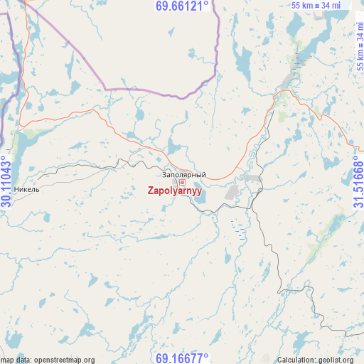
Zapolyarnyy GPS coordinates[2]
69° 24' 55.476" North, 30° 48' 48.78" East
| Map corner | latitude | longitude |
|---|---|---|
| Upper-left | 69.66121°, | 30.11043° |
| Center: | 69.41541°, | 30.81355° |
| Lower-right: | 69.16677°, | 31.51668° |
| Map W x H: | 55×55 km | = 34.2×34.2mi |
| max Lat: | 73.50819° ⇑0.2% North |
| Zapolyarnyy: | 69.41541° |
| min Lat: | ⇓99.8% South 41.28413° |
| min Long | Zapolyarnyy | max Long |
| -179.12198° | 30.81355° | 179.35046° |
| W 5.3%⇐ | ⇒94.7% E |
Elevation
Elevation of Zapolyarnyy is 128 m = 420 ft, and this is 74.6 m = 245 ft below average elevation for this country.
| Max E: |
2518 m = 8261 ft | 58.2% |
| Avg. | 202.6 m = 665 ft | |
| Zapolyarnyy | 128 m = 420 ft | |
Min E: |
-28 m = -92 ft | 41.8% |
See also: Russia elevation on elevation.city.
Geographical zone
Zapolyarnyy is located in North Frigid zone (between North Pole and Arctic Circle). Distance of this North polar circle is 317.1 km =197 mi to South.| Distance of | km | miles | from Zapolyarnyy |
|---|---|---|---|
| North Pole | 2288.8 | 1422.2 | to North |
| Arctic Circle | 317.1 | 197 | to South |
| Tropic Cancer | 5112.4 | 3176.7 | to South |
| Equator | 7718.3 | 4795.9 | to South |


Nearby cities:
15 places around Zapolyarnyy: (largest is in red/bold)
• Abram Mys
99.7 km =62 mi,  119°
119°
• Gadzhiyevo
100.6 km =62.5 mi,  100°
100°
• Kola
105.6 km =65.6 mi, 124°
• Murmansk
102.2 km =63.5 mi, 118°
• Murmashi
103.5 km =64.3 mi,  130°
130°
• Nikel
23.1 km =14.4 mi,  269°
269°
• Pechenga
18.6 km =11.6 mi,  48°
48°
• Polyarnyy
106.3 km =66.1 mi, 103°
• Roslyakovo
102.8 km =63.9 mi,  113°
113°
• Safonovo
105.5 km =65.6 mi, 111°
• Snezhnogorsk
99 km =61.5 mi, 104°
• Verkhnetulomskiy
98 km =60.9 mi,  156°
156°
• Vidyayevo
78.7 km =48.9 mi, 97°
• Vidyayevo
105.4 km =65.5 mi, 124°
• Zaozërsk
63.9 km =39.7 mi,  91°
91°
Sources, notices
• [Note1] Compared only with cities in Russia existing in our database
• [Src1] Map data: © OpenStreetMap contributors (CC-BY-SA)
• [Src2] Other city data from geonames.org with taken over terms of usage.
• [Src3] Geographical zone / Annual Mean Temperature by Robert A. Rohde @ Wikipedia
