Yukki geodata
Yukki (Leningradskaya Oblast') is a populated place; located in Russia in Europe/Moscow (GMT+3) time zone. With population of 698 people, there are 4820 cities with bigger population in this country. Compared to other cities in Russia, 91% of cities are located further ↓South; 96.1% of cities are located further →East and 85.3% of cities have higher elevation than Yukki. Note1


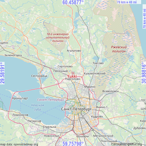
Yukki GPS coordinates[2]
60° 6' 36.864" North, 30° 17' 6.108" East
| Map corner | latitude | longitude |
|---|---|---|
| Upper-left | 60.45877°, | 29.58191° |
| Center: | 60.11024°, | 30.28503° |
| Lower-right: | 59.75798°, | 30.98816° |
| Map W x H: | 77.9×77.9 km | = 48.4×48.4mi |
| max Lat: | 73.50819° ⇑9% North |
| Yukki: | 60.11024° |
| min Lat: | ⇓91% South 41.28413° |
| min Long | Yukki | max Long |
| -179.12198° | 30.28503° | 179.35046° |
| W 3.9%⇐ | ⇒96.1% E |
Elevation
Elevation of Yukki is 46 m = 151 ft, and this is 156.6 m = 514 ft below average elevation for this country.
| Max E: |
2518 m = 8261 ft | 85.3% |
| Avg. | 202.6 m = 665 ft | |
| Yukki | 46 m = 151 ft | |
Min E: |
-28 m = -92 ft | 14.7% |
See also: Russia elevation on elevation.city.
Geographical zone
Yukki is located in North temperate zone (between Tropic of Cancer and the Arctic Circle). Distance of this North polar circle is 717.5 km =445.8 mi to North.| Distance of | km | miles | from Yukki |
|---|---|---|---|
| North Pole | 3323.4 | 2065.1 | to North |
| Arctic Circle | 717.5 | 445.8 | to North |
| Tropic Cancer | 4077.7 | 2533.8 | to South |
| Equator | 6683.6 | 4153 | to South |


Nearby cities:
15 places around Yukki: (largest is in red/bold)
• Bugry
7.4 km =4.6 mi,  126°
126°
• Grazhdanka
10.6 km =6.6 mi,  141°
141°
• Kolomyagi
9.6 km =6 mi,  180°
180°
• Levashovo
4.4 km =2.7 mi,  260°
260°
• Luppolovo
4.9 km =3 mi,  356°
356°
• Murino
11.6 km =7.2 mi, 126°
• Ozerki
8 km =5 mi,  169°
169°
• Pargolovo
3.3 km =2.1 mi,  188°
188°
• Parnas
5.7 km =3.5 mi, 141°
• Pesochnyy
6.9 km =4.3 mi,  281°
281°
• Sertolovo
6 km =3.7 mi,  309°
309°
• Shuvalovo
6.8 km =4.2 mi, 176°
• Sosnovka
11 km =6.8 mi,  160°
160°
• Udel’naya
10.6 km =6.6 mi, 170°
• Untolovo
11.7 km =7.3 mi,  201°
201°
Sources, notices
• [Note1] Compared only with cities in Russia existing in our database
• [Src1] Map data: © OpenStreetMap contributors (CC-BY-SA)
• [Src2] Other city data from geonames.org with taken over terms of usage.
• [Src3] Geographical zone / Annual Mean Temperature by Robert A. Rohde @ Wikipedia
