Shuvalovo geodata
Shuvalovo (St.-Petersburg) is a section of populated place; located in Russia in Europe/Moscow (GMT+3) time zone. With population of 6,000 people, there are 2258 cities with bigger population in this country. Compared to other cities in Russia, 90.7% of cities are located further ↓South; 96.1% of cities are located further →East and 90.7% of cities have higher elevation than Shuvalovo. Note1


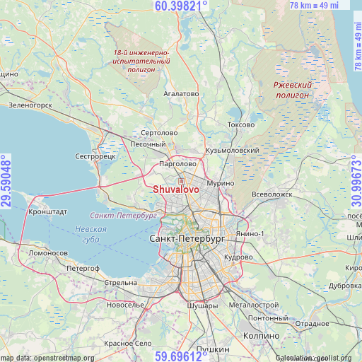
Shuvalovo GPS coordinates[2]
60° 2' 56.508" North, 30° 17' 36.96" East
| Map corner | latitude | longitude |
|---|---|---|
| Upper-left | 60.39821°, | 29.59048° |
| Center: | 60.04903°, | 30.2936° |
| Lower-right: | 59.69612°, | 30.99673° |
| Map W x H: | 78.1×78.1 km | = 48.5×48.5mi |
| max Lat: | 73.50819° ⇑9.3% North |
| Shuvalovo: | 60.04903° |
| min Lat: | ⇓90.7% South 41.28413° |
| min Long | Shuvalovo | max Long |
| -179.12198° | 30.2936° | 179.35046° |
| W 3.9%⇐ | ⇒96.1% E |
Elevation
Elevation of Shuvalovo is 26 m = 85 ft, and this is 176.6 m = 579 ft below average elevation for this country.
| Max E: |
2518 m = 8261 ft | 90.7% |
| Avg. | 202.6 m = 665 ft | |
| Shuvalovo | 26 m = 85 ft | |
Min E: |
-28 m = -92 ft | 9.3% |
See also: Russia elevation on elevation.city.
Geographical zone
Shuvalovo is located in North temperate zone (between Tropic of Cancer and the Arctic Circle). Distance of this North polar circle is 724.3 km =450.1 mi to North.| Distance of | km | miles | from Shuvalovo |
|---|---|---|---|
| North Pole | 3330.2 | 2069.3 | to North |
| Arctic Circle | 724.3 | 450.1 | to North |
| Tropic Cancer | 4070.9 | 2529.5 | to South |
| Equator | 6676.8 | 4148.8 | to South |


Nearby cities:
15 places around Shuvalovo: (largest is in red/bold)
• Akademicheskoe
6.9 km =4.3 mi,  124°
124°
• Bugry
6 km =3.7 mi,  65°
65°
• Chernaya Rechka
7 km =4.3 mi,  175°
175°
• Grazhdanka
6.4 km =4 mi,  103°
103°
• Kolomyagi
2.8 km =1.7 mi,  189°
189°
• Komendantsky aerodrom
5.1 km =3.2 mi, 191°
• Novaya Derevnya
6.9 km =4.3 mi, 183°
• Ozerki
1.4 km =0.9 mi,  137°
137°
• Pargolovo
3.7 km =2.3 mi,  344°
344°
• Parnas
3.8 km =2.4 mi,  53°
53°
• Sosnovka
4.8 km =3 mi, 138°
• Svetlanovskiy
5.5 km =3.4 mi,  158°
158°
• Udel’naya
3.9 km =2.4 mi, 159°
• Untolovo
6.2 km =3.9 mi,  228°
228°
• Yukki
6.8 km =4.2 mi,  356°
356°
Sources, notices
• [Note1] Compared only with cities in Russia existing in our database
• [Src1] Map data: © OpenStreetMap contributors (CC-BY-SA)
• [Src2] Other city data from geonames.org with taken over terms of usage.
• [Src3] Geographical zone / Annual Mean Temperature by Robert A. Rohde @ Wikipedia
