Yukhnov geodata
Yukhnov (Kaluga) is a populated place; located in Russia in Europe/Moscow (GMT+3) time zone. With population of 7,934 people, there are 1818 cities with bigger population in this country. Compared to other cities in Russia, 50.8% of cities are located further ↓South; 88.7% of cities are located further →East and 53.9% of cities have lower elevation than Yukhnov. Note1


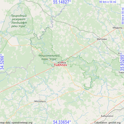
Yukhnov GPS coordinates[2]
54° 44' 39.984" North, 35° 13' 46.992" East
| Map corner | latitude | longitude |
|---|---|---|
| Upper-left | 55.14827°, | 34.5266° |
| Center: | 54.74444°, | 35.22972° |
| Lower-right: | 54.33654°, | 35.93285° |
| Map W x H: | 90.3×90.3 km | = 56.1×56.1mi |
| max Lat: | 73.50819° ⇑49.2% North |
| Yukhnov: | 54.74444° |
| min Lat: | ⇓50.8% South 41.28413° |
| min Long | Yukhnov | max Long |
| -179.12198° | 35.22972° | 179.35046° |
| W 11.3%⇐ | ⇒88.7% E |
Elevation
Elevation of Yukhnov is 154 m = 505 ft, and this is 48.6 m = 159 ft below average elevation for this country.
| Max E: |
2518 m = 8261 ft | 46.1% |
| Avg. | 202.6 m = 665 ft | |
| Yukhnov | 154 m = 505 ft | |
Min E: |
-28 m = -92 ft | 53.9% |
See also: Russia elevation on elevation.city.
Geographical zone
Yukhnov is located in North temperate zone (between Tropic of Cancer and the Arctic Circle). Distance of this North polar circle is 1314.2 km =816.6 mi to North.| Distance of | km | miles | from Yukhnov |
|---|---|---|---|
| North Pole | 3920.1 | 2435.8 | to North |
| Arctic Circle | 1314.2 | 816.6 | to North |
| Tropic Cancer | 3481.1 | 2163.1 | to South |
| Equator | 6087 | 3782.3 | to South |


Nearby cities:
15 places around Yukhnov: (largest is in red/bold)
• Babynino
52.3 km =32.5 mi,  138°
138°
• Dvortsy
51.3 km =31.9 mi,  106°
106°
• Iznoski
27.6 km =17.1 mi,  10°
10°
• Kondrovo
45.3 km =28.1 mi,  81°
81°
• Medyn’
47.4 km =29.5 mi,  58°
58°
• Meshchovsk
46.8 km =29.1 mi,  175°
175°
• Mosal’sk
32.7 km =20.3 mi,  209°
209°
• Myatlevo
33.2 km =20.6 mi, 59°
• Nikola-Lenivets
23.9 km =14.9 mi,  88°
88°
• Polotnyanyy Zavod
47.3 km =29.4 mi, 93°
• Pyatovskiy
53.4 km =33.2 mi,  96°
96°
• Saburovshchino
44.6 km =27.7 mi, 142°
• Tovarkovo
46.2 km =28.7 mi, 99°
• Tëmkino
42.8 km =26.6 mi,  341°
341°
• Zhiletovo
51.2 km =31.8 mi, 96°
Sources, notices
• [Note1] Compared only with cities in Russia existing in our database
• [Src1] Map data: © OpenStreetMap contributors (CC-BY-SA)
• [Src2] Other city data from geonames.org with taken over terms of usage.
• [Src3] Geographical zone / Annual Mean Temperature by Robert A. Rohde @ Wikipedia
