Dvortsy geodata
Dvortsy (Kaluga) is a populated place; located in Russia in Europe/Moscow (GMT+3) time zone. With population of 1,492 people, there are 4393 cities with bigger population in this country. Compared to other cities in Russia, 50.2% of cities are located further ↑North; 87.4% of cities are located further →East and 56.2% of cities have higher elevation than Dvortsy. Note1


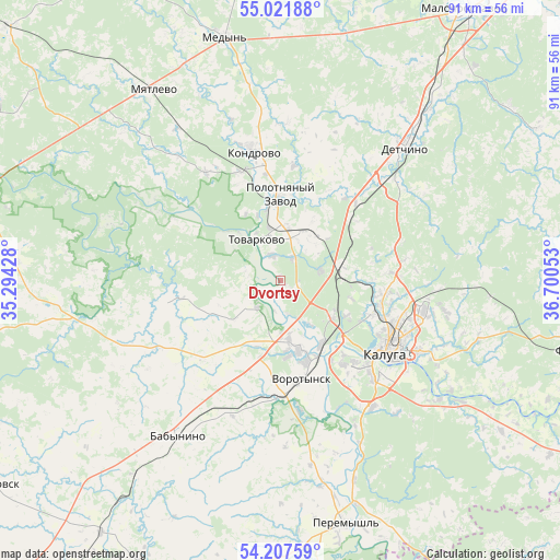
Dvortsy GPS coordinates[2]
54° 37' 0.372" North, 35° 59' 50.64" East
| Map corner | latitude | longitude |
|---|---|---|
| Upper-left | 55.02188°, | 35.29428° |
| Center: | 54.61677°, | 35.9974° |
| Lower-right: | 54.20759°, | 36.70053° |
| Map W x H: | 90.5×90.5 km | = 56.2×56.2mi |
| max Lat: | 73.50819° ⇑50.2% North |
| Dvortsy: | 54.61677° |
| min Lat: | ⇓49.8% South 41.28413° |
| min Long | Dvortsy | max Long |
| -179.12198° | 35.9974° | 179.35046° |
| W 12.6%⇐ | ⇒87.4% E |
Elevation
Elevation of Dvortsy is 132 m = 433 ft, and this is 70.6 m = 232 ft below average elevation for this country.
| Max E: |
2518 m = 8261 ft | 56.2% |
| Avg. | 202.6 m = 665 ft | |
| Dvortsy | 132 m = 433 ft | |
Min E: |
-28 m = -92 ft | 43.8% |
See also: Russia elevation on elevation.city.
Geographical zone
Dvortsy is located in North temperate zone (between Tropic of Cancer and the Arctic Circle). Distance of this North polar circle is 1328.4 km =825.4 mi to North.| Distance of | km | miles | from Dvortsy |
|---|---|---|---|
| North Pole | 3934.2 | 2444.6 | to North |
| Arctic Circle | 1328.4 | 825.4 | to North |
| Tropic Cancer | 3466.9 | 2154.2 | to South |
| Equator | 6072.8 | 3773.5 | to South |


Nearby cities:
15 places around Dvortsy: (largest is in red/bold)
• Avchurino
33 km =20.5 mi,  122°
122°
• Babynino
28.8 km =17.9 mi,  210°
210°
• Detchino
29.2 km =18.1 mi,  42°
42°
• Kaluga
20.4 km =12.7 mi, 118°
• Kondrovo
21.6 km =13.4 mi,  348°
348°
• Kurovskoye
8.2 km =5.1 mi,  177°
177°
• Mstikhino
10.5 km =6.5 mi,  127°
127°
• Myatlevo
37.4 km =23.2 mi,  326°
326°
• Nikola-Lenivets
29.4 km =18.3 mi,  300°
300°
• Polotnyanyy Zavod
11.8 km =7.3 mi, 350°
• Pyatovskiy
8.9 km =5.5 mi,  25°
25°
• Saburovshchino
30.7 km =19.1 mi,  226°
226°
• Tovarkovo
7.6 km =4.7 mi, 330°
• Vorotynsk
21.2 km =13.2 mi,  171°
171°
• Zhiletovo
8.5 km =5.3 mi,  10°
10°
Sources, notices
• [Note1] Compared only with cities in Russia existing in our database
• [Src1] Map data: © OpenStreetMap contributors (CC-BY-SA)
• [Src2] Other city data from geonames.org with taken over terms of usage.
• [Src3] Geographical zone / Annual Mean Temperature by Robert A. Rohde @ Wikipedia
