Ust’-Izhora geodata
Ust’-Izhora (St.-Petersburg) is a populated place; located in Russia in Europe/Moscow (GMT+3) time zone. With population of 1,354 people, there are 4447 cities with bigger population in this country. Compared to other cities in Russia, 89.1% of cities are located further ↓South; 95.1% of cities are located further →East and 94% of cities have higher elevation than Ust’-Izhora. Note1


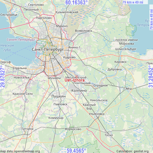
Ust’-Izhora GPS coordinates[2]
59° 48' 42.984" North, 30° 34' 53.004" East
| Map corner | latitude | longitude |
|---|---|---|
| Upper-left | 60.16363°, | 29.87827° |
| Center: | 59.81194°, | 30.58139° |
| Lower-right: | 59.4565°, | 31.28452° |
| Map W x H: | 78.6×78.6 km | = 48.8×48.8mi |
| max Lat: | 73.50819° ⇑10.9% North |
| Ust’-Izhora: | 59.81194° |
| min Lat: | ⇓89.1% South 41.28413° |
| min Long | Ust’-Izhora | max Long |
| -179.12198° | 30.58139° | 179.35046° |
| W 4.9%⇐ | ⇒95.1% E |
Elevation
Elevation of Ust’-Izhora is 15 m = 49 ft, and this is 187.6 m = 615 ft below average elevation for this country.
| Max E: |
2518 m = 8261 ft | 94% |
| Avg. | 202.6 m = 665 ft | |
| Ust’-Izhora | 15 m = 49 ft | |
Min E: |
-28 m = -92 ft | 6% |
See also: Russia elevation on elevation.city.
Geographical zone
Ust’-Izhora is located in North temperate zone (between Tropic of Cancer and the Arctic Circle). Distance of this North polar circle is 750.7 km =466.5 mi to North.| Distance of | km | miles | from Ust’-Izhora |
|---|---|---|---|
| North Pole | 3356.6 | 2085.7 | to North |
| Arctic Circle | 750.7 | 466.5 | to North |
| Tropic Cancer | 4044.5 | 2513.1 | to South |
| Equator | 6650.5 | 4132.4 | to South |


Nearby cities:
15 places around Ust’-Izhora: (largest is in red/bold)
• Imeni Sverdlova
5 km =3.1 mi,  110°
110°
• Kolpino
6.8 km =4.2 mi,  176°
176°
• Koltushi
13.6 km =8.5 mi,  15°
15°
• Kupchino
13.4 km =8.3 mi,  289°
289°
• Metallostroy
2.2 km =1.4 mi,  236°
236°
• Obukhovo
8.1 km =5 mi,  296°
296°
• Otradnoye
13.8 km =8.6 mi, 106°
• Petro-Slavyanka
4.3 km =2.7 mi,  255°
255°
• Pontonnyy
3.4 km =2.1 mi,  145°
145°
• Rybatskoye
5.5 km =3.4 mi, 303°
• Sapërnyy
6 km =3.7 mi,  131°
131°
• Shushary
11.2 km =7 mi,  268°
268°
• Staraya
13.1 km =8.1 mi,  11°
11°
• Tyarlevo
13.9 km =8.6 mi,  213°
213°
• Zanevka
14.7 km =9.1 mi,  344°
344°
Sources, notices
• [Note1] Compared only with cities in Russia existing in our database
• [Src1] Map data: © OpenStreetMap contributors (CC-BY-SA)
• [Src2] Other city data from geonames.org with taken over terms of usage.
• [Src3] Geographical zone / Annual Mean Temperature by Robert A. Rohde @ Wikipedia
