Pontonnyy geodata
Pontonnyy (St.-Petersburg) is a populated place; located in Russia in Europe/Moscow (GMT+3) time zone. With population of 9,001 people, there are 1652 cities with bigger population in this country. Compared to other cities in Russia, 89% of cities are located further ↓South; 95% of cities are located further →East and 92.8% of cities have higher elevation than Pontonnyy. Note1


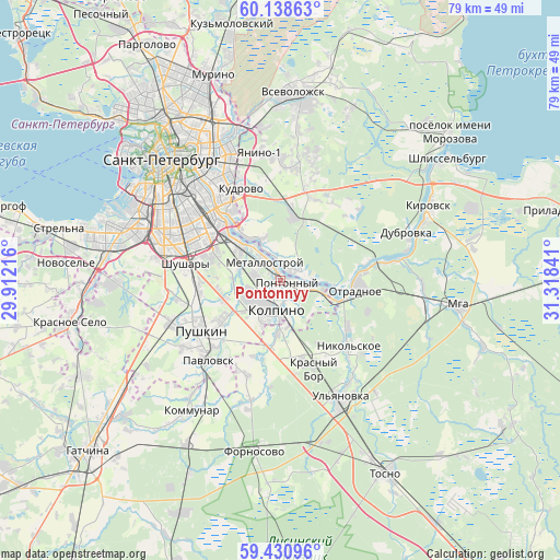
Pontonnyy GPS coordinates[2]
59° 47' 12.012" North, 30° 36' 55.008" East
| Map corner | latitude | longitude |
|---|---|---|
| Upper-left | 60.13863°, | 29.91216° |
| Center: | 59.78667°, | 30.61528° |
| Lower-right: | 59.43096°, | 31.31841° |
| Map W x H: | 78.7×78.7 km | = 48.9×48.9mi |
| max Lat: | 73.50819° ⇑11% North |
| Pontonnyy: | 59.78667° |
| min Lat: | ⇓89% South 41.28413° |
| min Long | Pontonnyy | max Long |
| -179.12198° | 30.61528° | 179.35046° |
| W 5%⇐ | ⇒95% E |
Elevation
Elevation of Pontonnyy is 19 m = 62 ft, and this is 183.6 m = 602 ft below average elevation for this country.
| Max E: |
2518 m = 8261 ft | 92.8% |
| Avg. | 202.6 m = 665 ft | |
| Pontonnyy | 19 m = 62 ft | |
Min E: |
-28 m = -92 ft | 7.2% |
See also: Russia elevation on elevation.city.
Geographical zone
Pontonnyy is located in North temperate zone (between Tropic of Cancer and the Arctic Circle). Distance of this North polar circle is 753.5 km =468.2 mi to North.| Distance of | km | miles | from Pontonnyy |
|---|---|---|---|
| North Pole | 3359.4 | 2087.4 | to North |
| Arctic Circle | 753.5 | 468.2 | to North |
| Tropic Cancer | 4041.7 | 2511.4 | to South |
| Equator | 6647.7 | 4130.7 | to South |


Nearby cities:
15 places around Pontonnyy: (largest is in red/bold)
• Fëdorovskoye
14.5 km =9 mi,  198°
198°
• Imeni Sverdlova
3 km =1.9 mi,  69°
69°
• Kolpino
4.3 km =2.7 mi, 200°
• Krasnyy Bor
12 km =7.5 mi,  165°
165°
• Metallostroy
4.1 km =2.5 mi,  292°
292°
• Nikol’skoye
13.5 km =8.4 mi,  135°
135°
• Obukhovo
11.2 km =7 mi,  304°
304°
• Otradnoye
11.4 km =7.1 mi,  95°
95°
• Petro-Slavyanka
6.3 km =3.9 mi, 285°
• Pushkin
14.7 km =9.1 mi,  236°
236°
• Rybatskoye
8.8 km =5.5 mi,  311°
311°
• Sapërnyy
2.8 km =1.7 mi,  114°
114°
• Shushary
13.3 km =8.3 mi,  280°
280°
• Tyarlevo
12.9 km =8 mi,  227°
227°
• Ust’-Izhora
3.4 km =2.1 mi,  325°
325°
Sources, notices
• [Note1] Compared only with cities in Russia existing in our database
• [Src1] Map data: © OpenStreetMap contributors (CC-BY-SA)
• [Src2] Other city data from geonames.org with taken over terms of usage.
• [Src3] Geographical zone / Annual Mean Temperature by Robert A. Rohde @ Wikipedia
