Teribërka geodata
Teribërka (Murmansk) is a populated place; located in Russia in Europe/Moscow (GMT+3) time zone. With population of 1,300 people, there are 4471 cities with bigger population in this country. Compared to other cities in Russia, 99.5% of cities are located further ↓South; 88.8% of cities are located further →East and 98.8% of cities have higher elevation than Teribërka. Note1


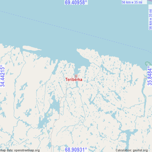
Teribërka GPS coordinates[2]
69° 9' 39.168" North, 35° 8' 42.972" East
| Map corner | latitude | longitude |
|---|---|---|
| Upper-left | 69.40958°, | 34.44215° |
| Center: | 69.16088°, | 35.14527° |
| Lower-right: | 68.90931°, | 35.8484° |
| Map W x H: | 55.6×55.6 km | = 34.5×34.5mi |
| max Lat: | 73.50819° ⇑0.5% North |
| Teribërka: | 69.16088° |
| min Lat: | ⇓99.5% South 41.28413° |
| min Long | Teribërka | max Long |
| -179.12198° | 35.14527° | 179.35046° |
| W 11.2%⇐ | ⇒88.8% E |
Elevation
Elevation of Teribërka is 1 m = 3 ft, and this is 201.6 m = 661 ft below average elevation for this country.
| Max E: |
2518 m = 8261 ft | 98.8% |
| Avg. | 202.6 m = 665 ft | |
| Teribërka | 1 m = 3 ft | |
Min E: |
-28 m = -92 ft | 1.2% |
See also: Russia elevation on elevation.city.
Geographical zone
Teribërka is located in North Frigid zone (between North Pole and Arctic Circle). Distance of this North polar circle is 288.8 km =179.5 mi to South.| Distance of | km | miles | from Teribërka |
|---|---|---|---|
| North Pole | 2317.1 | 1439.8 | to North |
| Arctic Circle | 288.8 | 179.5 | to South |
| Tropic Cancer | 5084.1 | 3159.1 | to South |
| Equator | 7690 | 4778.3 | to South |


Nearby cities:
15 places around Teribërka: (largest is in red/bold)
• Abram Mys
86.8 km =53.9 mi,  256°
256°
• Gadzhiyevo
72.2 km =44.9 mi,  278°
278°
• Kola
90.2 km =56 mi,  249°
249°
• Lodeynoye
3.1 km =1.9 mi,  338°
338°
• Molochnyy
91.3 km =56.7 mi, 248°
• Murmansk
84 km =52.2 mi, 256°
• Polyarnyy
67.2 km =41.8 mi,  273°
273°
• Roslyakovo
78.3 km =48.7 mi, 260°
• Safonovo
74.2 km =46.1 mi, 261°
• Severomorsk
69.3 km =43.1 mi, 261°
• Severomorsk-3
64.6 km =40.1 mi,  240°
240°
• Shonguy
91.8 km =57 mi, 240°
• Snezhnogorsk
74.9 km =46.5 mi, 272°
• Tumannyy
37.7 km =23.4 mi,  144°
144°
• Vidyayevo
90.2 km =56 mi, 249°
Sources, notices
• [Note1] Compared only with cities in Russia existing in our database
• [Src1] Map data: © OpenStreetMap contributors (CC-BY-SA)
• [Src2] Other city data from geonames.org with taken over terms of usage.
• [Src3] Geographical zone / Annual Mean Temperature by Robert A. Rohde @ Wikipedia
