Shonguy geodata
Shonguy (Murmansk) is a populated place; located in Russia in Europe/Moscow (GMT+3) time zone. With population of 1,122 people, there are 4564 cities with bigger population in this country. Compared to other cities in Russia, 99.2% of cities are located further ↓South; 91.9% of cities are located further →East and 92.5% of cities have higher elevation than Shonguy. Note1


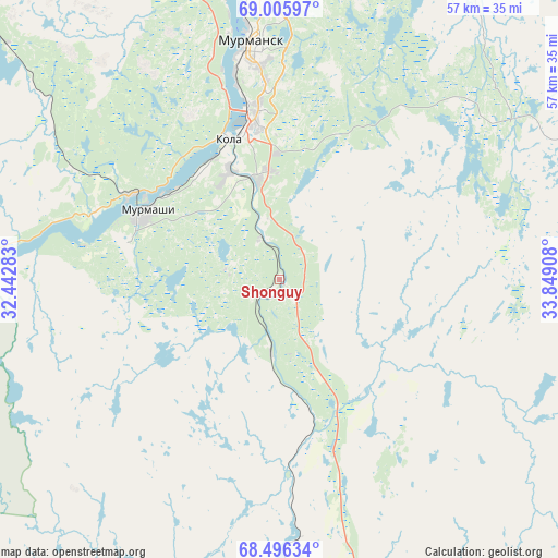
Shonguy GPS coordinates[2]
68° 45' 9.396" North, 33° 8' 45.42" East
| Map corner | latitude | longitude |
|---|---|---|
| Upper-left | 69.00597°, | 32.44283° |
| Center: | 68.75261°, | 33.14595° |
| Lower-right: | 68.49634°, | 33.84908° |
| Map W x H: | 56.7×56.7 km | = 35.2×35.2mi |
| max Lat: | 73.50819° ⇑0.8% North |
| Shonguy: | 68.75261° |
| min Lat: | ⇓99.2% South 41.28413° |
| min Long | Shonguy | max Long |
| -179.12198° | 33.14595° | 179.35046° |
| W 8.1%⇐ | ⇒91.9% E |
Elevation
Elevation of Shonguy is 20 m = 66 ft, and this is 182.6 m = 599 ft below average elevation for this country.
| Max E: |
2518 m = 8261 ft | 92.5% |
| Avg. | 202.6 m = 665 ft | |
| Shonguy | 20 m = 66 ft | |
Min E: |
-28 m = -92 ft | 7.5% |
See also: Russia elevation on elevation.city.
Geographical zone
Shonguy is located in North Frigid zone (between North Pole and Arctic Circle). Distance of this North polar circle is 243.4 km =151.2 mi to South.| Distance of | km | miles | from Shonguy |
|---|---|---|---|
| North Pole | 2362.5 | 1468 | to North |
| Arctic Circle | 243.4 | 151.2 | to South |
| Tropic Cancer | 5038.7 | 3130.9 | to South |
| Equator | 7644.6 | 4750.1 | to South |


Nearby cities:
15 places around Shonguy: (largest is in red/bold)
• Abram Mys
25.6 km =15.9 mi,  348°
348°
• Gadzhiyevo
56.4 km =35 mi,  7°
7°
• Kola
15.1 km =9.4 mi,  340°
340°
• Molochnyy
12.3 km =7.6 mi, 335°
• Murmansk
25.3 km =15.7 mi,  355°
355°
• Murmashi
15.2 km =9.4 mi,  297°
297°
• Polyarnyy
51.1 km =31.8 mi, 13°
• Roslyakovo
32.4 km =20.1 mi,  3°
3°
• Safonovo
34.7 km =21.6 mi, 9°
• Severomorsk
36.8 km =22.9 mi,  17°
17°
• Severomorsk-3
27.2 km =16.9 mi,  59°
59°
• Snezhnogorsk
49.2 km =30.6 mi, 4°
• Verkhnetulomskiy
56.9 km =35.4 mi,  253°
253°
• Vidyayevo
15.4 km =9.6 mi, 340°
• Vidyayevo
64.4 km =40 mi, 347°
Sources, notices
• [Note1] Compared only with cities in Russia existing in our database
• [Src1] Map data: © OpenStreetMap contributors (CC-BY-SA)
• [Src2] Other city data from geonames.org with taken over terms of usage.
• [Src3] Geographical zone / Annual Mean Temperature by Robert A. Rohde @ Wikipedia
