Taman’ geodata
Taman’ (Krasnodarskiy) is a populated place; located in Russia in Europe/Moscow (GMT+3) time zone. With population of 9,417 people, there are 1600 cities with bigger population in this country. Compared to other cities in Russia, 86.4% of cities are located further ↑North; 85.6% of cities are located further →East and 93.7% of cities have higher elevation than Taman’. Note1


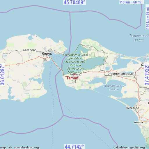
Taman’ GPS coordinates[2]
45° 12' 42.12" North, 36° 42' 57.924" East
| Map corner | latitude | longitude |
|---|---|---|
| Upper-left | 45.70489°, | 36.01297° |
| Center: | 45.2117°, | 36.71609° |
| Lower-right: | 44.7142°, | 37.41922° |
| Map W x H: | 110.2×110.2 km | = 68.5×68.5mi |
| max Lat: | 73.50819° ⇑86.4% North |
| Taman’: | 45.2117° |
| min Lat: | ⇓13.6% South 41.28413° |
| min Long | Taman’ | max Long |
| -179.12198° | 36.71609° | 179.35046° |
| W 14.4%⇐ | ⇒85.6% E |
Elevation
Elevation of Taman’ is 16 m = 52 ft, and this is 186.6 m = 612 ft below average elevation for this country.
| Max E: |
2518 m = 8261 ft | 93.7% |
| Avg. | 202.6 m = 665 ft | |
| Taman’ | 16 m = 52 ft | |
Min E: |
-28 m = -92 ft | 6.3% |
See also: Russia elevation on elevation.city.
Geographical zone
Taman’ is located in North temperate zone (between Tropic of Cancer and the Arctic Circle). Distance of this North polar circle is 2374.1 km =1475.2 mi to North.| Distance of | km | miles | from Taman’ |
|---|---|---|---|
| North Pole | 4980 | 3094.4 | to North |
| Arctic Circle | 2374.1 | 1475.2 | to North |
| Tropic Cancer | 2421.2 | 1504.5 | to South |
| Equator | 5027.1 | 3123.7 | to South |


Nearby cities:
15 places around Taman’: (largest is in red/bold)
• Akhtanizovskaya
32.5 km =20.2 mi,  67°
67°
• Blagovetschenskaya
37 km =23 mi,  118°
118°
• Dzhiginka
49.5 km =30.8 mi,  100°
100°
• Golubitskaya
45.2 km =28.1 mi, 73°
• Il’ich
24.1 km =15 mi,  10°
10°
• Kontenko
18.6 km =11.6 mi,  29°
29°
• Kuchugury
28.7 km =17.8 mi,  40°
40°
• Starotitarovskaya
34.4 km =21.4 mi,  88°
88°
• Strelka
44.7 km =27.8 mi, 90°
• Temryuk
52.9 km =32.9 mi,  82°
82°
• Tsibanobalka
55.6 km =34.5 mi, 117°
• Vinogradnyy
50.5 km =31.4 mi,  110°
110°
• Vityazevo
50.2 km =31.2 mi, 117°
• Vyshestebliyevskaya
23.7 km =14.7 mi, 94°
• Yurovka
56.1 km =34.9 mi, 101°
Sources, notices
• [Note1] Compared only with cities in Russia existing in our database
• [Src1] Map data: © OpenStreetMap contributors (CC-BY-SA)
• [Src2] Other city data from geonames.org with taken over terms of usage.
• [Src3] Geographical zone / Annual Mean Temperature by Robert A. Rohde @ Wikipedia
