Sylva geodata
Sylva (Perm) is a populated place; located in Russia in Asia/Yekaterinburg (GMT+5) time zone. With population of 7,655 people, there are 1876 cities with bigger population in this country. Compared to other cities in Russia, 82.8% of cities are located further ↓South; 68.4% of cities are located further ←West and 60.6% of cities have lower elevation than Sylva. Note1


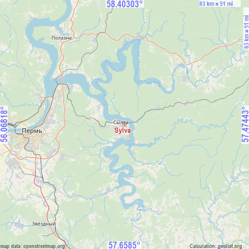
Sylva GPS coordinates[2]
58° 1' 57.72" North, 56° 46' 16.68" East
| Map corner | latitude | longitude |
|---|---|---|
| Upper-left | 58.40303°, | 56.06818° |
| Center: | 58.0327°, | 56.7713° |
| Lower-right: | 57.6585°, | 57.47443° |
| Map W x H: | 82.8×82.8 km | = 51.4×51.4mi |
| max Lat: | 73.50819° ⇑17.2% North |
| Sylva: | 58.0327° |
| min Lat: | ⇓82.8% South 41.28413° |
| min Long | Sylva | max Long |
| -179.12198° | 56.7713° | 179.35046° |
| W 68.4%⇐ | ⇒31.6% E |
Elevation
Elevation of Sylva is 170 m = 558 ft, and this is 32.6 m = 107 ft below average elevation for this country.
| Max E: |
2518 m = 8261 ft | 39.4% |
| Avg. | 202.6 m = 665 ft | |
| Sylva | 170 m = 558 ft | |
Min E: |
-28 m = -92 ft | 60.6% |
See also: Russia elevation on elevation.city.
Geographical zone
Sylva is located in North temperate zone (between Tropic of Cancer and the Arctic Circle). Distance of this North polar circle is 948.5 km =589.4 mi to North.| Distance of | km | miles | from Sylva |
|---|---|---|---|
| North Pole | 3554.4 | 2208.6 | to North |
| Arctic Circle | 948.5 | 589.4 | to North |
| Tropic Cancer | 3846.7 | 2390.2 | to South |
| Equator | 6452.6 | 4009.5 | to South |


Nearby cities:
15 places around Sylva: (largest is in red/bold)
• Bershet’
40.8 km =25.4 mi,  214°
214°
• Ferma
31.1 km =19.3 mi,  242°
242°
• Froly
31.9 km =19.8 mi,  247°
247°
• Gamovo
43.5 km =27 mi, 244°
• Komarikhinskiy
21.5 km =13.4 mi,  70°
70°
• Kondratovo
39.6 km =24.6 mi,  261°
261°
• Kukushtan
46 km =28.6 mi,  200°
200°
• Lobanovo
33.7 km =20.9 mi, 235°
• Novyye Lyady
9.8 km =6.1 mi,  284°
284°
• Perm
30.8 km =19.1 mi,  265°
265°
• Polazna
35.6 km =22.1 mi,  324°
324°
• Sokol
44.8 km =27.8 mi, 252°
• Verkhnechusovskiye Gorodki
24.8 km =15.4 mi,  52°
52°
• Yug
48.9 km =30.4 mi,  226°
226°
• Zvëzdnyy
42.9 km =26.7 mi,  218°
218°
Sources, notices
• [Note1] Compared only with cities in Russia existing in our database
• [Src1] Map data: © OpenStreetMap contributors (CC-BY-SA)
• [Src2] Other city data from geonames.org with taken over terms of usage.
• [Src3] Geographical zone / Annual Mean Temperature by Robert A. Rohde @ Wikipedia
