Stavrovo geodata
Stavrovo (Vladimir) is a populated place; located in Russia in Europe/Moscow (GMT+3) time zone. With population of 7,822 people, there are 1848 cities with bigger population in this country. Compared to other cities in Russia, 68.4% of cities are located further ↓South; 67.4% of cities are located further →East and 63.9% of cities have higher elevation than Stavrovo. Note1


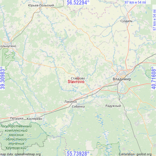
Stavrovo GPS coordinates[2]
56° 7' 59.196" North, 40° 0' 46.62" East
| Map corner | latitude | longitude |
|---|---|---|
| Upper-left | 56.52294°, | 39.30983° |
| Center: | 56.13311°, | 40.01295° |
| Lower-right: | 55.73928°, | 40.71608° |
| Map W x H: | 87.1×87.1 km | = 54.1×54.1mi |
| max Lat: | 73.50819° ⇑31.6% North |
| Stavrovo: | 56.13311° |
| min Lat: | ⇓68.4% South 41.28413° |
| min Long | Stavrovo | max Long |
| -179.12198° | 40.01295° | 179.35046° |
| W 32.6%⇐ | ⇒67.4% E |
Elevation
Elevation of Stavrovo is 116 m = 381 ft, and this is 86.6 m = 284 ft below average elevation for this country.
| Max E: |
2518 m = 8261 ft | 63.9% |
| Avg. | 202.6 m = 665 ft | |
| Stavrovo | 116 m = 381 ft | |
Min E: |
-28 m = -92 ft | 36.1% |
See also: Russia elevation on elevation.city.
Geographical zone
Stavrovo is located in North temperate zone (between Tropic of Cancer and the Arctic Circle). Distance of this North polar circle is 1159.8 km =720.7 mi to North.| Distance of | km | miles | from Stavrovo |
|---|---|---|---|
| North Pole | 3765.6 | 2339.8 | to North |
| Arctic Circle | 1159.8 | 720.7 | to North |
| Tropic Cancer | 3635.5 | 2259 | to South |
| Equator | 6241.4 | 3878.2 | to South |


Nearby cities:
15 places around Stavrovo: (largest is in red/bold)
• Bavleny
40.1 km =24.9 mi,  316°
316°
• Belaya Rechka
41.1 km =25.5 mi,  294°
294°
• Bogolyubovo
32.2 km =20 mi,  78°
78°
• Golovino
31.9 km =19.8 mi,  126°
126°
• Kol’chugino
43.1 km =26.8 mi,  295°
295°
• Kommunar
27 km =16.8 mi,  94°
94°
• Kosterevo
33.5 km =20.8 mi,  227°
227°
• Lakinsk
13.3 km =8.3 mi,  197°
197°
• Orgtrud
37.7 km =23.4 mi, 81°
• Petushki
41.3 km =25.7 mi,  236°
236°
• Raduzhnyy
24.8 km =15.4 mi, 125°
• Sobinka
16.4 km =10.2 mi,  180°
180°
• Suzdal’
41.9 km =26 mi,  39°
39°
• Vladimir
23.8 km =14.8 mi, 89°
• Vorsha
10.2 km =6.3 mi,  156°
156°
Sources, notices
• [Note1] Compared only with cities in Russia existing in our database
• [Src1] Map data: © OpenStreetMap contributors (CC-BY-SA)
• [Src2] Other city data from geonames.org with taken over terms of usage.
• [Src3] Geographical zone / Annual Mean Temperature by Robert A. Rohde @ Wikipedia
