Kol’chugino geodata
Kol’chugino (Vladimir) is a populated place; located in Russia in Europe/Moscow (GMT+3) time zone. With population of 45,912 people, there are 459 cities with bigger population in this country. Compared to other cities in Russia, 70.6% of cities are located further ↓South; 70.6% of cities are located further →East and 63.8% of cities have lower elevation than Kol’chugino. Note1


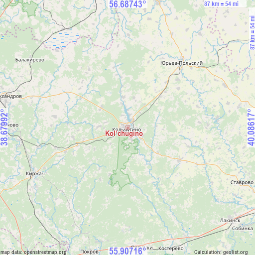
Kol’chugino GPS coordinates[2]
56° 17' 57.444" North, 39° 22' 58.944" East
| Map corner | latitude | longitude |
|---|---|---|
| Upper-left | 56.68743°, | 38.67992° |
| Center: | 56.29929°, | 39.38304° |
| Lower-right: | 55.90716°, | 40.08617° |
| Map W x H: | 86.8×86.8 km | = 53.9×53.9mi |
| max Lat: | 73.50819° ⇑29.4% North |
| Kol’chugino: | 56.29929° |
| min Lat: | ⇓70.6% South 41.28413° |
| min Long | Kol’chugino | max Long |
| -179.12198° | 39.38304° | 179.35046° |
| W 29.4%⇐ | ⇒70.6% E |
Elevation
Elevation of Kol’chugino is 179 m = 587 ft, and this is 23.6 m = 77 ft below average elevation for this country.
| Max E: |
2518 m = 8261 ft | 36.2% |
| Avg. | 202.6 m = 665 ft | |
| Kol’chugino | 179 m = 587 ft | |
Min E: |
-28 m = -92 ft | 63.8% |
See also: Kol’chugino elevation on elevation.city.
Geographical zone
Kol’chugino is located in North temperate zone (between Tropic of Cancer and the Arctic Circle). Distance of this North polar circle is 1141.3 km =709.2 mi to North.| Distance of | km | miles | from Kol’chugino |
|---|---|---|---|
| North Pole | 3747.2 | 2328.4 | to North |
| Arctic Circle | 1141.3 | 709.2 | to North |
| Tropic Cancer | 3654 | 2270.5 | to South |
| Equator | 6259.9 | 3889.7 | to South |


Nearby cities:
15 places around Kol’chugino: (largest is in red/bold)
• Aleksandrov
42.7 km =26.5 mi,  284°
284°
• Balakirevo
40.4 km =25.1 mi,  304°
304°
• Bavleny
15.4 km =9.6 mi,  46°
46°
• Belaya Rechka
2.2 km =1.4 mi,  137°
137°
• Berendeyevo
40.2 km =25 mi,  326°
326°
• Karabanovo
42.2 km =26.2 mi,  272°
272°
• Kirzhach
36.5 km =22.7 mi,  243°
243°
• Kosterevo
43.5 km =27 mi,  160°
160°
• Krasnyy Oktyabr’
37 km =23 mi, 236°
• Lakinsk
46.9 km =29.1 mi,  131°
131°
• Petushki
41.7 km =25.9 mi,  173°
173°
• Pokrov
44.4 km =27.6 mi,  197°
197°
• Stavrovo
43.1 km =26.8 mi,  115°
115°
• Strunino
50 km =31.1 mi, 279°
• Yur’yev-Pol’skiy
29.1 km =18.1 mi,  38°
38°
Sources, notices
• [Note1] Compared only with cities in Russia existing in our database
• [Src1] Map data: © OpenStreetMap contributors (CC-BY-SA)
• [Src2] Other city data from geonames.org with taken over terms of usage.
• [Src3] Geographical zone / Annual Mean Temperature by Robert A. Rohde @ Wikipedia
