Sovetskiy geodata
Sovetskiy (Leningradskaya Oblast') is a populated place; located in Russia in Europe/Moscow (GMT+3) time zone. With population of 6,574 people, there are 2109 cities with bigger population in this country. Compared to other cities in Russia, 92.2% of cities are located further ↓South; 98.5% of cities are located further →East and 92.5% of cities have higher elevation than Sovetskiy. Note1


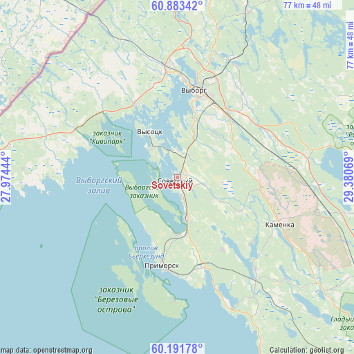
Sovetskiy GPS coordinates[2]
60° 32' 22.02" North, 28° 40' 39.216" East
| Map corner | latitude | longitude |
|---|---|---|
| Upper-left | 60.88342°, | 27.97444° |
| Center: | 60.53945°, | 28.67756° |
| Lower-right: | 60.19178°, | 29.38069° |
| Map W x H: | 76.9×76.9 km | = 47.8×47.8mi |
| max Lat: | 73.50819° ⇑7.8% North |
| Sovetskiy: | 60.53945° |
| min Lat: | ⇓92.2% South 41.28413° |
| min Long | Sovetskiy | max Long |
| -179.12198° | 28.67756° | 179.35046° |
| W 1.5%⇐ | ⇒98.5% E |
Elevation
Elevation of Sovetskiy is 20 m = 66 ft, and this is 182.6 m = 599 ft below average elevation for this country.
| Max E: |
2518 m = 8261 ft | 92.5% |
| Avg. | 202.6 m = 665 ft | |
| Sovetskiy | 20 m = 66 ft | |
Min E: |
-28 m = -92 ft | 7.5% |
See also: Russia elevation on elevation.city.
Geographical zone
Sovetskiy is located in North temperate zone (between Tropic of Cancer and the Arctic Circle). Distance of this North polar circle is 669.8 km =416.2 mi to North.| Distance of | km | miles | from Sovetskiy |
|---|---|---|---|
| North Pole | 3275.7 | 2035.4 | to North |
| Arctic Circle | 669.8 | 416.2 | to North |
| Tropic Cancer | 4125.4 | 2563.4 | to South |
| Equator | 6731.4 | 4182.7 | to South |


Nearby cities:
15 places around Sovetskiy: (largest is in red/bold)
• Glebychevo
11.4 km =7.1 mi,  168°
168°
• Kamenka
24.5 km =15.2 mi,  114°
114°
• Kamennogorsk
52.4 km =32.6 mi,  28°
28°
• Korobitsyno
57.3 km =35.6 mi,  92°
92°
• Lesogorskiy
57.9 km =36 mi,  13°
13°
• Molodezhnoye
59.7 km =37.1 mi,  129°
129°
• Pervomayskoye
61.7 km =38.3 mi, 108°
• Primorsk
19.7 km =12.2 mi,  191°
191°
• Roshchino
60.3 km =37.5 mi,  122°
122°
• Semiozerje
41.8 km =26 mi, 125°
• Smolyachkovo
59.4 km =36.9 mi, 132°
• Veshchevo
34.8 km =21.6 mi,  52°
52°
• Vyborg
19.1 km =11.9 mi, 12°
• Vysotsk
11.5 km =7.1 mi,  329°
329°
• Yakovlevo
52.2 km =32.4 mi, 121°
Sources, notices
• [Note1] Compared only with cities in Russia existing in our database
• [Src1] Map data: © OpenStreetMap contributors (CC-BY-SA)
• [Src2] Other city data from geonames.org with taken over terms of usage.
• [Src3] Geographical zone / Annual Mean Temperature by Robert A. Rohde @ Wikipedia
