Pervomayskoye geodata
Pervomayskoye (Leningradskaya Oblast') is a populated place; located in Russia in Europe/Moscow (GMT+3) time zone. With population of 4,473 people, there are 2878 cities with bigger population in this country. Compared to other cities in Russia, 91.8% of cities are located further ↓South; 97.6% of cities are located further →East and 72.6% of cities have higher elevation than Pervomayskoye. Note1


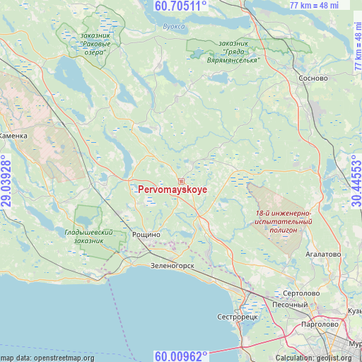
Pervomayskoye GPS coordinates[2]
60° 21' 33.192" North, 29° 44' 32.64" East
| Map corner | latitude | longitude |
|---|---|---|
| Upper-left | 60.70511°, | 29.03928° |
| Center: | 60.35922°, | 29.7424° |
| Lower-right: | 60.00962°, | 30.44553° |
| Map W x H: | 77.3×77.3 km | = 48×48mi |
| max Lat: | 73.50819° ⇑8.2% North |
| Pervomayskoye: | 60.35922° |
| min Lat: | ⇓91.8% South 41.28413° |
| min Long | Pervomayskoye | max Long |
| -179.12198° | 29.7424° | 179.35046° |
| W 2.4%⇐ | ⇒97.6% E |
Elevation
Elevation of Pervomayskoye is 95 m = 312 ft, and this is 107.6 m = 353 ft below average elevation for this country.
| Max E: |
2518 m = 8261 ft | 72.6% |
| Avg. | 202.6 m = 665 ft | |
| Pervomayskoye | 95 m = 312 ft | |
Min E: |
-28 m = -92 ft | 27.4% |
See also: Russia elevation on elevation.city.
Geographical zone
Pervomayskoye is located in North temperate zone (between Tropic of Cancer and the Arctic Circle). Distance of this North polar circle is 689.9 km =428.7 mi to North.| Distance of | km | miles | from Pervomayskoye |
|---|---|---|---|
| North Pole | 3295.7 | 2047.9 | to North |
| Arctic Circle | 689.9 | 428.7 | to North |
| Tropic Cancer | 4105.4 | 2551 | to South |
| Equator | 6711.3 | 4170.2 | to South |


Nearby cities:
15 places around Pervomayskoye: (largest is in red/bold)
• Il’ichëvo
10.1 km =6.3 mi,  176°
176°
• Komarovo
19.5 km =12.1 mi,  169°
169°
• Korobitsyno
17.4 km =10.8 mi,  356°
356°
• Kurortnyy
23.4 km =14.5 mi,  157°
157°
• Leninskoye
16.5 km =10.3 mi, 159°
• Michurinskoye
23.7 km =14.7 mi,  16°
16°
• Molodezhnoye
21.8 km =13.5 mi,  214°
214°
• Repino
21.9 km =13.6 mi, 161°
• Roshchino
14 km =8.7 mi, 211°
• Semiozerje
24.9 km =15.5 mi,  259°
259°
• Smolyachkovo
24.8 km =15.4 mi,  216°
216°
• Solnechnoye
25.3 km =15.7 mi,  153°
153°
• Ushkovo
18.6 km =11.6 mi,  200°
200°
• Yakovlevo
15.8 km =9.8 mi,  242°
242°
• Zelenogorsk
17.9 km =11.1 mi,  187°
187°
Sources, notices
• [Note1] Compared only with cities in Russia existing in our database
• [Src1] Map data: © OpenStreetMap contributors (CC-BY-SA)
• [Src2] Other city data from geonames.org with taken over terms of usage.
• [Src3] Geographical zone / Annual Mean Temperature by Robert A. Rohde @ Wikipedia
