Shiringushi geodata
Shiringushi (Mordoviya Republic) is a populated place; located in Russia in Europe/Moscow (GMT+3) time zone. With population of 2,369 people, there are 4011 cities with bigger population in this country. Compared to other cities in Russia, 56.4% of cities are located further ↑North; 57.6% of cities are located further →East and 56.2% of cities have higher elevation than Shiringushi. Note1


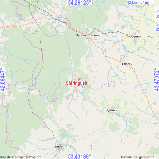
Shiringushi GPS coordinates[2]
53° 50' 54.636" North, 42° 46' 3.324" East
| Map corner | latitude | longitude |
|---|---|---|
| Upper-left | 54.26125°, | 42.06447° |
| Center: | 53.84851°, | 42.76759° |
| Lower-right: | 53.43166°, | 43.47072° |
| Map W x H: | 92.2×92.2 km | = 57.3×57.3mi |
| max Lat: | 73.50819° ⇑56.4% North |
| Shiringushi: | 53.84851° |
| min Lat: | ⇓43.6% South 41.28413° |
| min Long | Shiringushi | max Long |
| -179.12198° | 42.76759° | 179.35046° |
| W 42.4%⇐ | ⇒57.6% E |
Elevation
Elevation of Shiringushi is 132 m = 433 ft, and this is 70.6 m = 232 ft below average elevation for this country.
| Max E: |
2518 m = 8261 ft | 56.2% |
| Avg. | 202.6 m = 665 ft | |
| Shiringushi | 132 m = 433 ft | |
Min E: |
-28 m = -92 ft | 43.8% |
See also: Russia elevation on elevation.city.
Geographical zone
Shiringushi is located in North temperate zone (between Tropic of Cancer and the Arctic Circle). Distance of this North polar circle is 1413.8 km =878.5 mi to North.| Distance of | km | miles | from Shiringushi |
|---|---|---|---|
| North Pole | 4019.7 | 2497.7 | to North |
| Arctic Circle | 1413.8 | 878.5 | to North |
| Tropic Cancer | 3381.5 | 2101.2 | to South |
| Equator | 5987.4 | 3720.4 | to South |


Nearby cities:
15 places around Shiringushi: (largest is in red/bold)
• Bol’shaya Izhmora
33 km =20.5 mi,  172°
172°
• Dubrovki
36.1 km =22.4 mi,  93°
93°
• Klyuchi
29.1 km =18.1 mi,  162°
162°
• Lepley
51.6 km =32.1 mi,  6°
6°
• Rakhmanovka
33.2 km =20.6 mi,  152°
152°
• Spassk
28.6 km =17.8 mi,  72°
72°
• Torbeyevo
40.6 km =25.2 mi,  50°
50°
• Udarnyy
55.1 km =34.2 mi, 6°
• Umet
30.1 km =18.7 mi,  351°
351°
• Vadinsk
25.8 km =16 mi,  132°
132°
• Vyazëmka
27.8 km =17.3 mi,  192°
192°
• Vysha
25.6 km =15.9 mi,  269°
269°
• Yambirno
53.7 km =33.4 mi,  304°
304°
• Zemetchino
40.3 km =25 mi, 194°
• Zubova Polyana
25.8 km =16 mi, 10°
Sources, notices
• [Note1] Compared only with cities in Russia existing in our database
• [Src1] Map data: © OpenStreetMap contributors (CC-BY-SA)
• [Src2] Other city data from geonames.org with taken over terms of usage.
• [Src3] Geographical zone / Annual Mean Temperature by Robert A. Rohde @ Wikipedia
