Torbeyevo geodata
Torbeyevo (Mordoviya Republic) is a populated place; located in Russia in Europe/Moscow (GMT+3) time zone. With population of 9,138 people, there are 1634 cities with bigger population in this country. Compared to other cities in Russia, 54.5% of cities are located further ↑North; 55.6% of cities are located further →East and 67.1% of cities have lower elevation than Torbeyevo. Note1


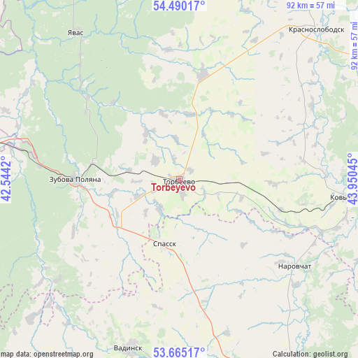
Torbeyevo GPS coordinates[2]
54° 4' 46.992" North, 43° 14' 50.352" East
| Map corner | latitude | longitude |
|---|---|---|
| Upper-left | 54.49017°, | 42.5442° |
| Center: | 54.07972°, | 43.24732° |
| Lower-right: | 53.66517°, | 43.95045° |
| Map W x H: | 91.7×91.7 km | = 57×57mi |
| max Lat: | 73.50819° ⇑54.5% North |
| Torbeyevo: | 54.07972° |
| min Lat: | ⇓45.5% South 41.28413° |
| min Long | Torbeyevo | max Long |
| -179.12198° | 43.24732° | 179.35046° |
| W 44.4%⇐ | ⇒55.6% E |
Elevation
Elevation of Torbeyevo is 188 m = 617 ft, and this is 14.6 m = 48 ft below average elevation for this country.
| Max E: |
2518 m = 8261 ft | 32.9% |
| Avg. | 202.6 m = 665 ft | |
| Torbeyevo | 188 m = 617 ft | |
Min E: |
-28 m = -92 ft | 67.1% |
See also: Russia elevation on elevation.city.
Geographical zone
Torbeyevo is located in North temperate zone (between Tropic of Cancer and the Arctic Circle). Distance of this North polar circle is 1388.1 km =862.5 mi to North.| Distance of | km | miles | from Torbeyevo |
|---|---|---|---|
| North Pole | 3994 | 2481.8 | to North |
| Arctic Circle | 1388.1 | 862.5 | to North |
| Tropic Cancer | 3407.2 | 2117.1 | to South |
| Equator | 6013.1 | 3736.4 | to South |


Nearby cities:
15 places around Torbeyevo: (largest is in red/bold)
• Barashevo
55.7 km =34.6 mi,  334°
334°
• Dubrovki
28.5 km =17.7 mi,  170°
170°
• Kovylkino
43.7 km =27.2 mi,  95°
95°
• Krasnoslobodsk
52.1 km =32.4 mi,  42°
42°
• Lepley
35.9 km =22.3 mi,  315°
315°
• Narovchat
37 km =23 mi,  127°
127°
• Partsa
40.5 km =25.2 mi, 321°
• Shiringushi
40.6 km =25.2 mi,  230°
230°
• Skanovo
41 km =25.5 mi, 125°
• Spassk
17.6 km =10.9 mi,  193°
193°
• Udarnyy
38.4 km =23.9 mi, 319°
• Umet
36.1 km =22.4 mi,  276°
276°
• Vadinsk
44.9 km =27.9 mi,  196°
196°
• Yavas
45.5 km =28.3 mi, 325°
• Zubova Polyana
26.8 km =16.7 mi,  269°
269°
Sources, notices
• [Note1] Compared only with cities in Russia existing in our database
• [Src1] Map data: © OpenStreetMap contributors (CC-BY-SA)
• [Src2] Other city data from geonames.org with taken over terms of usage.
• [Src3] Geographical zone / Annual Mean Temperature by Robert A. Rohde @ Wikipedia
