Shabel’skoye geodata
Shabel’skoye (Krasnodarskiy) is a populated place; located in Russia in Europe/Moscow (GMT+3) time zone. With population of 2,500 people, there are 3954 cities with bigger population in this country. Compared to other cities in Russia, 82.4% of cities are located further ↑North; 74.5% of cities are located further →East and 92.2% of cities have higher elevation than Shabel’skoye. Note1


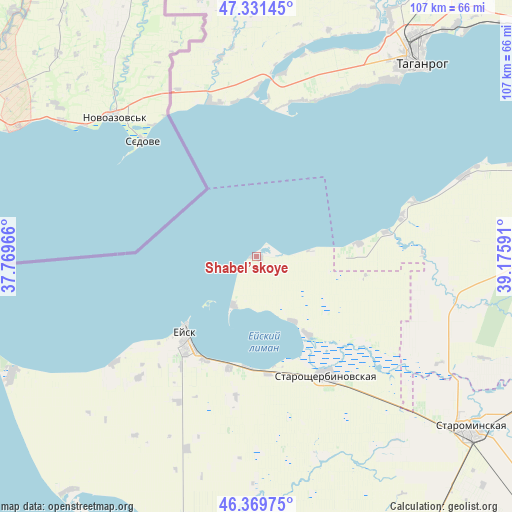
Shabel’skoye GPS coordinates[2]
46° 51' 9.9" North, 38° 28' 22.008" East
| Map corner | latitude | longitude |
|---|---|---|
| Upper-left | 47.33145°, | 37.76966° |
| Center: | 46.85275°, | 38.47278° |
| Lower-right: | 46.36975°, | 39.17591° |
| Map W x H: | 106.9×106.9 km | = 66.4×66.4mi |
| max Lat: | 73.50819° ⇑82.4% North |
| Shabel’skoye: | 46.85275° |
| min Lat: | ⇓17.6% South 41.28413° |
| min Long | Shabel’skoye | max Long |
| -179.12198° | 38.47278° | 179.35046° |
| W 25.5%⇐ | ⇒74.5% E |
Elevation
Elevation of Shabel’skoye is 21 m = 69 ft, and this is 181.6 m = 596 ft below average elevation for this country.
| Max E: |
2518 m = 8261 ft | 92.2% |
| Avg. | 202.6 m = 665 ft | |
| Shabel’skoye | 21 m = 69 ft | |
Min E: |
-28 m = -92 ft | 7.8% |
See also: Russia elevation on elevation.city.
Geographical zone
Shabel’skoye is located in North temperate zone (between Tropic of Cancer and the Arctic Circle). Distance of this North polar circle is 2191.6 km =1361.8 mi to North.| Distance of | km | miles | from Shabel’skoye |
|---|---|---|---|
| North Pole | 4797.5 | 2981 | to North |
| Arctic Circle | 2191.6 | 1361.8 | to North |
| Tropic Cancer | 2603.6 | 1617.8 | to South |
| Equator | 5209.5 | 3237 | to South |


Nearby cities:
15 places around Shabel’skoye: (largest is in red/bold)
• Dolzhanskaya
56.6 km =35.2 mi,  244°
244°
• Glafirovka
11.1 km =6.9 mi,  206°
206°
• Kanelovskaya
62.3 km =38.7 mi,  118°
118°
• Novobessergenovka
46.5 km =28.9 mi,  37°
37°
• Novoderevyankovskaya
62.5 km =38.8 mi,  160°
160°
• Novoshcherbinovskaya
43.9 km =27.3 mi, 162°
• Port-Katon
21.7 km =13.5 mi,  82°
82°
• Shirochanka
23.3 km =14.5 mi,  194°
194°
• Starominskaya
56.8 km =35.3 mi,  129°
129°
• Staroshcherbinovskaya
29 km =18 mi,  148°
148°
• Taganrog
53.4 km =33.2 mi, 37°
• Vorontsovka
37.4 km =23.2 mi,  233°
233°
• Yasenskaya
57 km =35.4 mi,  195°
195°
• Yeysk
22.3 km =13.9 mi,  222°
222°
• Yeyskoye Ukrepleniye
19.4 km =12.1 mi, 146°
Sources, notices
• [Note1] Compared only with cities in Russia existing in our database
• [Src1] Map data: © OpenStreetMap contributors (CC-BY-SA)
• [Src2] Other city data from geonames.org with taken over terms of usage.
• [Src3] Geographical zone / Annual Mean Temperature by Robert A. Rohde @ Wikipedia
