Kanelovskaya geodata
Kanelovskaya (Krasnodarskiy) is a populated place; located in Russia in Europe/Moscow (GMT+3) time zone. With population of 4,332 people, there are 2935 cities with bigger population in this country. Compared to other cities in Russia, 82.8% of cities are located further ↑North; 71.2% of cities are located further →East and 97.1% of cities have higher elevation than Kanelovskaya. Note1


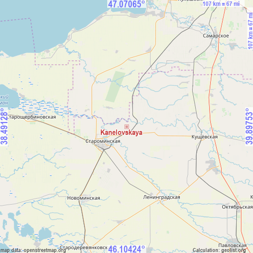
Kanelovskaya GPS coordinates[2]
46° 35' 22.56" North, 39° 11' 39.84" East
| Map corner | latitude | longitude |
|---|---|---|
| Upper-left | 47.07065°, | 38.49128° |
| Center: | 46.5896°, | 39.1944° |
| Lower-right: | 46.10424°, | 39.89753° |
| Map W x H: | 107.5×107.5 km | = 66.8×66.8mi |
| max Lat: | 73.50819° ⇑82.8% North |
| Kanelovskaya: | 46.5896° |
| min Lat: | ⇓17.2% South 41.28413° |
| min Long | Kanelovskaya | max Long |
| -179.12198° | 39.1944° | 179.35046° |
| W 28.8%⇐ | ⇒71.2% E |
Elevation
Elevation of Kanelovskaya is 7 m = 23 ft, and this is 195.6 m = 642 ft below average elevation for this country.
| Max E: |
2518 m = 8261 ft | 97.1% |
| Avg. | 202.6 m = 665 ft | |
| Kanelovskaya | 7 m = 23 ft | |
Min E: |
-28 m = -92 ft | 2.9% |
See also: Russia elevation on elevation.city.
Geographical zone
Kanelovskaya is located in North temperate zone (between Tropic of Cancer and the Arctic Circle). Distance of this North polar circle is 2220.9 km =1380 mi to North.| Distance of | km | miles | from Kanelovskaya |
|---|---|---|---|
| North Pole | 4826.8 | 2999.2 | to North |
| Arctic Circle | 2220.9 | 1380 | to North |
| Tropic Cancer | 2574.4 | 1599.7 | to South |
| Equator | 5180.3 | 3218.9 | to South |


Nearby cities:
15 places around Kanelovskaya: (largest is in red/bold)
• Kislyakovskaya
40.3 km =25 mi,  114°
114°
• Krasnoye
32.7 km =20.3 mi,  59°
59°
• Krylovskaya
54 km =33.6 mi,  171°
171°
• Kushchëvskaya
33.6 km =20.9 mi,  95°
95°
• Leningradskaya
33.3 km =20.7 mi,  153°
153°
• Novoderevyankovskaya
45.3 km =28.1 mi,  229°
229°
• Novominskaya
35.4 km =22 mi,  210°
210°
• Novoshcherbinovskaya
43.7 km =27.2 mi,  253°
253°
• Peshkovo
49.9 km =31 mi,  17°
17°
• Port-Katon
46.4 km =28.8 mi,  313°
313°
• Samarskoye
53.9 km =33.5 mi,  44°
44°
• Shkurinskaya
12.7 km =7.9 mi,  91°
91°
• Starominskaya
12.9 km =8 mi,  239°
239°
• Staroshcherbinovskaya
40 km =24.9 mi,  276°
276°
• Yeyskoye Ukrepleniye
46.3 km =28.8 mi,  286°
286°
Sources, notices
• [Note1] Compared only with cities in Russia existing in our database
• [Src1] Map data: © OpenStreetMap contributors (CC-BY-SA)
• [Src2] Other city data from geonames.org with taken over terms of usage.
• [Src3] Geographical zone / Annual Mean Temperature by Robert A. Rohde @ Wikipedia
