Setun’ geodata
Setun’ (Moscow) is a section of populated place; located in Russia in Europe/Moscow (GMT+3) time zone. With population of 20,000 people, there are 859 cities with bigger population in this country. Compared to other cities in Russia, 62% of cities are located further ↓South; 82.6% of cities are located further →East and 50.2% of cities have higher elevation than Setun’. Note1


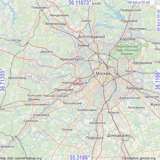
Setun’ GPS coordinates[2]
55° 43' 0.012" North, 37° 25' 0.012" East
| Map corner | latitude | longitude |
|---|---|---|
| Upper-left | 56.11073°, | 36.71355° |
| Center: | 55.71667°, | 37.41667° |
| Lower-right: | 55.3186°, | 38.1198° |
| Map W x H: | 88.1×88.1 km | = 54.7×54.7mi |
| max Lat: | 73.50819° ⇑38% North |
| Setun’: | 55.71667° |
| min Lat: | ⇓62% South 41.28413° |
| min Long | Setun’ | max Long |
| -179.12198° | 37.41667° | 179.35046° |
| W 17.4%⇐ | ⇒82.6% E |
Elevation
Elevation of Setun’ is 144 m = 472 ft, and this is 58.6 m = 192 ft below average elevation for this country.
| Max E: |
2518 m = 8261 ft | 50.2% |
| Avg. | 202.6 m = 665 ft | |
| Setun’ | 144 m = 472 ft | |
Min E: |
-28 m = -92 ft | 49.8% |
See also: Russia elevation on elevation.city.
Geographical zone
Setun’ is located in North temperate zone (between Tropic of Cancer and the Arctic Circle). Distance of this North polar circle is 1206.1 km =749.4 mi to North.| Distance of | km | miles | from Setun’ |
|---|---|---|---|
| North Pole | 3811.9 | 2368.6 | to North |
| Arctic Circle | 1206.1 | 749.4 | to North |
| Tropic Cancer | 3589.2 | 2230.2 | to South |
| Equator | 6195.1 | 3849.5 | to South |


Nearby cities:
15 places around Setun’: (largest is in red/bold)
• Amin’yevo
3.6 km =2.2 mi,  120°
120°
• Bol’shaya Setun’
0 km =0 mi,  0°
0°
• Davydkovo
3.5 km =2.2 mi,  87°
87°
• Fili
5.3 km =3.3 mi,  48°
48°
• Kastanayevo
5.2 km =3.2 mi, 90°
• Marfino
2.6 km =1.6 mi,  233°
233°
• Matveyevskoye
3.7 km =2.3 mi,  99°
99°
• Mikhalkovo
3.9 km =2.4 mi,  164°
164°
• Nemchinovka
3.6 km =2.2 mi,  281°
281°
• Nikol’skoye
5.6 km =3.5 mi,  131°
131°
• Novoivanovskoye
3.5 km =2.2 mi,  246°
246°
• Ochakovo-Matveyevskoye
4.1 km =2.5 mi,  152°
152°
• Ramenki
5.5 km =3.4 mi,  109°
109°
• Skolkovo
4.4 km =2.7 mi,  223°
223°
• Zarech’ye
3.7 km =2.3 mi,  204°
204°
Sources, notices
• [Note1] Compared only with cities in Russia existing in our database
• [Src1] Map data: © OpenStreetMap contributors (CC-BY-SA)
• [Src2] Other city data from geonames.org with taken over terms of usage.
• [Src3] Geographical zone / Annual Mean Temperature by Robert A. Rohde @ Wikipedia
