Nemchinovka geodata
Nemchinovka (Moscow Oblast) is a populated place; located in Russia in Europe/Moscow (GMT+3) time zone. With population of 4,938 people, there are 2693 cities with bigger population in this country. Compared to other cities in Russia, 62.2% of cities are located further ↓South; 83% of cities are located further →East and 63.6% of cities have lower elevation than Nemchinovka. Note1


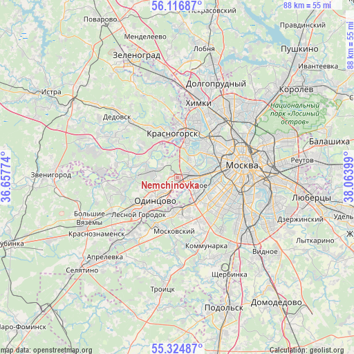
Nemchinovka GPS coordinates[2]
55° 43' 22.368" North, 37° 21' 39.096" East
| Map corner | latitude | longitude |
|---|---|---|
| Upper-left | 56.11687°, | 36.65774° |
| Center: | 55.72288°, | 37.36086° |
| Lower-right: | 55.32487°, | 38.06399° |
| Map W x H: | 88.1×88.1 km | = 54.7×54.7mi |
| max Lat: | 73.50819° ⇑37.8% North |
| Nemchinovka: | 55.72288° |
| min Lat: | ⇓62.2% South 41.28413° |
| min Long | Nemchinovka | max Long |
| -179.12198° | 37.36086° | 179.35046° |
| W 17%⇐ | ⇒83% E |
Elevation
Elevation of Nemchinovka is 178 m = 584 ft, and this is 24.6 m = 81 ft below average elevation for this country.
| Max E: |
2518 m = 8261 ft | 36.4% |
| Avg. | 202.6 m = 665 ft | |
| Nemchinovka | 178 m = 584 ft | |
Min E: |
-28 m = -92 ft | 63.6% |
See also: Russia elevation on elevation.city.
Geographical zone
Nemchinovka is located in North temperate zone (between Tropic of Cancer and the Arctic Circle). Distance of this North polar circle is 1205.4 km =749 mi to North.| Distance of | km | miles | from Nemchinovka |
|---|---|---|---|
| North Pole | 3811.3 | 2368.2 | to North |
| Arctic Circle | 1205.4 | 749 | to North |
| Tropic Cancer | 3589.9 | 2230.7 | to South |
| Equator | 6195.8 | 3849.9 | to South |


Nearby cities:
15 places around Nemchinovka: (largest is in red/bold)
• Amin’yevo
7.1 km =4.4 mi,  110°
110°
• Barvikha
5.5 km =3.4 mi,  292°
292°
• Bol’shaya Setun’
3.6 km =2.2 mi,  101°
101°
• Davydkovo
7 km =4.3 mi,  94°
94°
• Fili
8 km =5 mi,  69°
69°
• Marfino
2.6 km =1.6 mi,  148°
148°
• Matveyevskoye
7.3 km =4.5 mi, 100°
• Mikhalkovo
6.3 km =3.9 mi,  134°
134°
• Novoivanovskoye
2.1 km =1.3 mi,  172°
172°
• Ochakovo-Matveyevskoye
6.9 km =4.3 mi, 128°
• Odintsovo
7.2 km =4.5 mi,  226°
226°
• Rublëvo
6.9 km =4.3 mi,  356°
356°
• Setun’
3.6 km =2.2 mi, 101°
• Skolkovo
3.9 km =2.4 mi, 173°
• Zarech’ye
4.5 km =2.8 mi, 153°
Sources, notices
• [Note1] Compared only with cities in Russia existing in our database
• [Src1] Map data: © OpenStreetMap contributors (CC-BY-SA)
• [Src2] Other city data from geonames.org with taken over terms of usage.
• [Src3] Geographical zone / Annual Mean Temperature by Robert A. Rohde @ Wikipedia
