Selyatino geodata
Selyatino (Moscow Oblast) is a populated place; located in Russia in Europe/Moscow (GMT+3) time zone. With population of 12,954 people, there are 1210 cities with bigger population in this country. Compared to other cities in Russia, 58.3% of cities are located further ↓South; 84.9% of cities are located further →East and 71.5% of cities have lower elevation than Selyatino. Note1


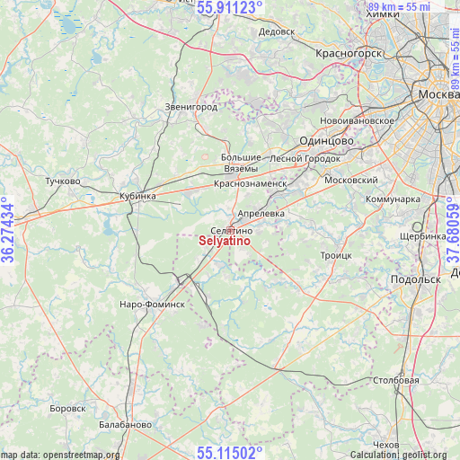
Selyatino GPS coordinates[2]
55° 30' 54.504" North, 36° 58' 38.856" East
| Map corner | latitude | longitude |
|---|---|---|
| Upper-left | 55.91123°, | 36.27434° |
| Center: | 55.51514°, | 36.97746° |
| Lower-right: | 55.11502°, | 37.68059° |
| Map W x H: | 88.5×88.5 km | = 55×55mi |
| max Lat: | 73.50819° ⇑41.7% North |
| Selyatino: | 55.51514° |
| min Lat: | ⇓58.3% South 41.28413° |
| min Long | Selyatino | max Long |
| -179.12198° | 36.97746° | 179.35046° |
| W 15.1%⇐ | ⇒84.9% E |
Elevation
Elevation of Selyatino is 202 m = 663 ft, and this is 0.59999999999999 m = 2 ft below average elevation for this country.
| Max E: |
2518 m = 8261 ft | 28.5% |
| Avg. | 202.6 m = 665 ft | |
| Selyatino | 202 m = 663 ft | |
Min E: |
-28 m = -92 ft | 71.5% |
See also: Russia elevation on elevation.city.
Geographical zone
Selyatino is located in North temperate zone (between Tropic of Cancer and the Arctic Circle). Distance of this North polar circle is 1228.5 km =763.4 mi to North.| Distance of | km | miles | from Selyatino |
|---|---|---|---|
| North Pole | 3834.4 | 2382.6 | to North |
| Arctic Circle | 1228.5 | 763.4 | to North |
| Tropic Cancer | 3566.8 | 2216.3 | to South |
| Equator | 6172.7 | 3835.5 | to South |


Nearby cities:
15 places around Selyatino: (largest is in red/bold)
• Alabino
2.4 km =1.5 mi,  57°
57°
• Annino
19.3 km =12 mi,  66°
66°
• Aprelevka
7.6 km =4.7 mi, 57°
• Bol'shiye Vyazëmy
11.7 km =7.3 mi,  359°
359°
• Golitsyno
10.5 km =6.5 mi,  1°
1°
• Kievskiy
11.8 km =7.3 mi,  216°
216°
• Kokoshkino
15.2 km =9.4 mi,  52°
52°
• Krasnaya Pahra
20.6 km =12.8 mi,  116°
116°
• Krasnoznamensk
10.1 km =6.3 mi,  22°
22°
• Kubinka
18.6 km =11.6 mi,  292°
292°
• Lesnoy Gorodok
20 km =12.4 mi, 46°
• Nazar'yevo
18.1 km =11.2 mi,  12°
12°
• Shishkin Les
17.7 km =11 mi,  131°
131°
• Tolstopal’tsevo
18.5 km =11.5 mi, 55°
• Zhavoronki
16.8 km =10.4 mi,  27°
27°
Sources, notices
• [Note1] Compared only with cities in Russia existing in our database
• [Src1] Map data: © OpenStreetMap contributors (CC-BY-SA)
• [Src2] Other city data from geonames.org with taken over terms of usage.
• [Src3] Geographical zone / Annual Mean Temperature by Robert A. Rohde @ Wikipedia
