Rybnoye geodata
Rybnoye (Ryazan Oblast) is a populated place; located in Russia in Europe/Moscow (GMT+3) time zone. With population of 19,159 people, there are 907 cities with bigger population in this country. Compared to other cities in Russia, 50.7% of cities are located further ↓South; 70% of cities are located further →East and 69.3% of cities have higher elevation than Rybnoye. Note1


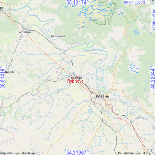
Rybnoye GPS coordinates[2]
54° 43' 39.864" North, 39° 31' 2.316" East
| Map corner | latitude | longitude |
|---|---|---|
| Upper-left | 55.13174°, | 38.81419° |
| Center: | 54.72774°, | 39.51731° |
| Lower-right: | 54.31967°, | 40.22044° |
| Map W x H: | 90.3×90.3 km | = 56.1×56.1mi |
| max Lat: | 73.50819° ⇑49.3% North |
| Rybnoye: | 54.72774° |
| min Lat: | ⇓50.7% South 41.28413° |
| min Long | Rybnoye | max Long |
| -179.12198° | 39.51731° | 179.35046° |
| W 30%⇐ | ⇒70% E |
Elevation
Elevation of Rybnoye is 104 m = 341 ft, and this is 98.6 m = 323 ft below average elevation for this country.
| Max E: |
2518 m = 8261 ft | 69.3% |
| Avg. | 202.6 m = 665 ft | |
| Rybnoye | 104 m = 341 ft | |
Min E: |
-28 m = -92 ft | 30.7% |
See also: Russia elevation on elevation.city.
Geographical zone
Rybnoye is located in North temperate zone (between Tropic of Cancer and the Arctic Circle). Distance of this North polar circle is 1316 km =817.7 mi to North.| Distance of | km | miles | from Rybnoye |
|---|---|---|---|
| North Pole | 3921.9 | 2437 | to North |
| Arctic Circle | 1316 | 817.7 | to North |
| Tropic Cancer | 3479.2 | 2161.9 | to South |
| Equator | 6085.2 | 3781.2 | to South |


Nearby cities:
15 places around Rybnoye: (largest is in red/bold)
• Bagramovo
4.2 km =2.6 mi,  263°
263°
• Beloomut
26.7 km =16.6 mi,  334°
334°
• Kolomna
61.3 km =38.1 mi,  309°
309°
• Krasnaya Poyma
41.3 km =25.7 mi,  317°
317°
• Kuz’minskoye
18 km =11.2 mi,  30°
30°
• Lukhovitsy
41 km =25.5 mi, 312°
• Murmino
37.2 km =23.1 mi,  111°
111°
• Polyany
20.1 km =12.5 mi,  93°
93°
• Radovitskiy
47.9 km =29.8 mi,  21°
21°
• Ryazan’
15.9 km =9.9 mi,  135°
135°
• Sel’nikovo
50.9 km =31.6 mi, 333°
• Serebryanyye Prudy
58.8 km =36.5 mi,  240°
240°
• Solotcha
21.4 km =13.3 mi,  71°
71°
• Zakharovo
43.1 km =26.8 mi,  200°
200°
• Zaraysk
41.2 km =25.6 mi,  275°
275°
Sources, notices
• [Note1] Compared only with cities in Russia existing in our database
• [Src1] Map data: © OpenStreetMap contributors (CC-BY-SA)
• [Src2] Other city data from geonames.org with taken over terms of usage.
• [Src3] Geographical zone / Annual Mean Temperature by Robert A. Rohde @ Wikipedia
