Polessk geodata
Polessk (Kaliningrad) is a seat of a second-order administrative division; located in Russia in Europe/Kaliningrad (GMT+2) time zone. With population of 7,835 people, there are 1841 cities with bigger population in this country. Compared to other cities in Russia, 51.7% of cities are located further ↓South; 99.4% of cities are located further →East and 98.3% of cities have higher elevation than Polessk. Note1


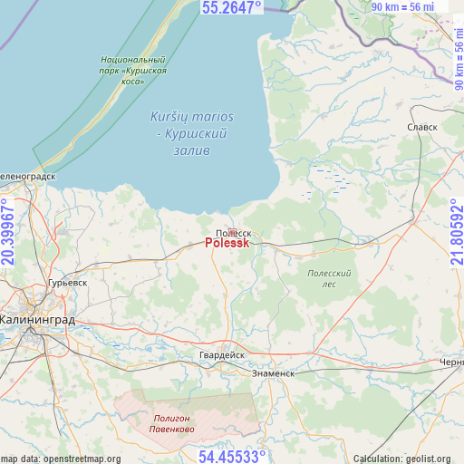
Polessk GPS coordinates[2]
54° 51' 43.38" North, 21° 6' 10.044" East
| Map corner | latitude | longitude |
|---|---|---|
| Upper-left | 55.2647°, | 20.39967° |
| Center: | 54.86205°, | 21.10279° |
| Lower-right: | 54.45533°, | 21.80592° |
| Map W x H: | 90×90 km | = 55.9×55.9mi |
| max Lat: | 73.50819° ⇑48.3% North |
| Polessk: | 54.86205° |
| min Lat: | ⇓51.7% South 41.28413° |
| min Long | Polessk | max Long |
| -179.12198° | 21.10279° | 179.35046° |
| W 0.6%⇐ | ⇒99.4% E |
Elevation
Elevation of Polessk is 3 m = 10 ft, and this is 199.6 m = 655 ft below average elevation for this country.
| Max E: |
2518 m = 8261 ft | 98.3% |
| Avg. | 202.6 m = 665 ft | |
| Polessk | 3 m = 10 ft | |
Min E: |
-28 m = -92 ft | 1.7% |
See also: Russia elevation on elevation.city.
Geographical zone
Polessk is located in North temperate zone (between Tropic of Cancer and the Arctic Circle). Distance of this North polar circle is 1301.1 km =808.5 mi to North.| Distance of | km | miles | from Polessk |
|---|---|---|---|
| North Pole | 3907 | 2427.7 | to North |
| Arctic Circle | 1301.1 | 808.5 | to North |
| Tropic Cancer | 3494.2 | 2171.2 | to South |
| Equator | 6100.1 | 3790.4 | to South |


Nearby cities:
15 places around Polessk: (largest is in red/bold)
• Bol'shoe Isakovo
35.8 km =22.2 mi,  243°
243°
• Chernyakhovsk
52.3 km =32.5 mi,  119°
119°
• Gur’yevsk
33.4 km =20.8 mi,  252°
252°
• Gvardeysk
24 km =14.9 mi,  185°
185°
• Kaliningrad
41.7 km =25.9 mi, 245°
• Khrabrovo
33.6 km =20.9 mi,  276°
276°
• Lesnoy
35.2 km =21.9 mi,  298°
298°
• Maloye Isakovo
36.2 km =22.5 mi, 246°
• Nizov’ye
29.4 km =18.3 mi,  232°
232°
• Pravdinsk
46.9 km =29.1 mi, 186°
• Rybachiy
36.3 km =22.6 mi,  333°
333°
• Slavsk
41.8 km =26 mi,  61°
61°
• Yuzhnyy
47.6 km =29.6 mi,  222°
222°
• Zelenogradsk
41.4 km =25.7 mi,  285°
285°
• Znamensk
28.7 km =17.8 mi,  163°
163°
Sources, notices
• [Note1] Compared only with cities in Russia existing in our database
• [Src1] Map data: © OpenStreetMap contributors (CC-BY-SA)
• [Src2] Other city data from geonames.org with taken over terms of usage.
• [Src3] Geographical zone / Annual Mean Temperature by Robert A. Rohde @ Wikipedia
