Khrabrovo geodata
Khrabrovo (Kaliningrad) is a populated place; located in Russia in Europe/Kaliningrad (GMT+2) time zone. With population of 2,143 people, there are 4099 cities with bigger population in this country. Compared to other cities in Russia, 52.1% of cities are located further ↓South; 99.6% of cities are located further →East and 96.4% of cities have higher elevation than Khrabrovo. Note1


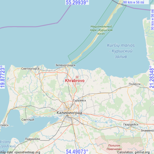
Khrabrovo GPS coordinates[2]
54° 53' 49.524" North, 20° 34' 49.26" East
| Map corner | latitude | longitude |
|---|---|---|
| Upper-left | 55.29939°, | 19.87723° |
| Center: | 54.89709°, | 20.58035° |
| Lower-right: | 54.49073°, | 21.28348° |
| Map W x H: | 89.9×89.9 km | = 55.9×55.9mi |
| max Lat: | 73.50819° ⇑47.9% North |
| Khrabrovo: | 54.89709° |
| min Lat: | ⇓52.1% South 41.28413° |
| min Long | Khrabrovo | max Long |
| -179.12198° | 20.58035° | 179.35046° |
| W 0.4%⇐ | ⇒99.6% E |
Elevation
Elevation of Khrabrovo is 9 m = 30 ft, and this is 193.6 m = 635 ft below average elevation for this country.
| Max E: |
2518 m = 8261 ft | 96.4% |
| Avg. | 202.6 m = 665 ft | |
| Khrabrovo | 9 m = 30 ft | |
Min E: |
-28 m = -92 ft | 3.6% |
See also: Russia elevation on elevation.city.
Geographical zone
Khrabrovo is located in North temperate zone (between Tropic of Cancer and the Arctic Circle). Distance of this North polar circle is 1297.2 km =806 mi to North.| Distance of | km | miles | from Khrabrovo |
|---|---|---|---|
| North Pole | 3903.1 | 2425.3 | to North |
| Arctic Circle | 1297.2 | 806 | to North |
| Tropic Cancer | 3498.1 | 2173.6 | to South |
| Equator | 6104 | 3792.8 | to South |


Nearby cities:
15 places around Khrabrovo: (largest is in red/bold)
• Bol'shoe Isakovo
20 km =12.4 mi,  175°
175°
• Gur’yevsk
13.9 km =8.6 mi,  173°
173°
• Kaliningrad
21.7 km =13.5 mi,  191°
191°
• Lesnoy
13.1 km =8.1 mi,  10°
10°
• Maloye Isakovo
18.3 km =11.4 mi, 179°
• Nizov’ye
23.9 km =14.9 mi,  155°
155°
• Otradnoye
30.2 km =18.8 mi,  279°
279°
• Pionerskiy
23.3 km =14.5 mi, 284°
• Polessk
33.6 km =20.9 mi,  96°
96°
• Rybachiy
33.4 km =20.8 mi,  31°
31°
• Svetlogorsk
27.6 km =17.1 mi, 279°
• Svetlyy
37.8 km =23.5 mi,  229°
229°
• Volochayevskoye
31.8 km =19.8 mi, 226°
• Vzmorye
31.4 km =19.5 mi,  224°
224°
• Zelenogradsk
9.5 km =5.9 mi,  316°
316°
Sources, notices
• [Note1] Compared only with cities in Russia existing in our database
• [Src1] Map data: © OpenStreetMap contributors (CC-BY-SA)
• [Src2] Other city data from geonames.org with taken over terms of usage.
• [Src3] Geographical zone / Annual Mean Temperature by Robert A. Rohde @ Wikipedia
