Pichayevo geodata
Pichayevo (Tambov) is a populated place; located in Russia in Europe/Moscow (GMT+3) time zone. With population of 3,463 people, there are 3425 cities with bigger population in this country. Compared to other cities in Russia, 61.1% of cities are located further ↑North; 59% of cities are located further →East and 52.6% of cities have higher elevation than Pichayevo. Note1


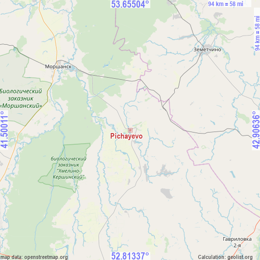
Pichayevo GPS coordinates[2]
53° 14' 10.572" North, 42° 12' 11.628" East
| Map corner | latitude | longitude |
|---|---|---|
| Upper-left | 53.65504°, | 41.50011° |
| Center: | 53.23627°, | 42.20323° |
| Lower-right: | 52.81337°, | 42.90636° |
| Map W x H: | 93.6×93.6 km | = 58.2×58.2mi |
| max Lat: | 73.50819° ⇑61.1% North |
| Pichayevo: | 53.23627° |
| min Lat: | ⇓38.9% South 41.28413° |
| min Long | Pichayevo | max Long |
| -179.12198° | 42.20323° | 179.35046° |
| W 41%⇐ | ⇒59% E |
Elevation
Elevation of Pichayevo is 139 m = 456 ft, and this is 63.6 m = 209 ft below average elevation for this country.
| Max E: |
2518 m = 8261 ft | 52.6% |
| Avg. | 202.6 m = 665 ft | |
| Pichayevo | 139 m = 456 ft | |
Min E: |
-28 m = -92 ft | 47.4% |
See also: Russia elevation on elevation.city.
Geographical zone
Pichayevo is located in North temperate zone (between Tropic of Cancer and the Arctic Circle). Distance of this North polar circle is 1481.9 km =920.8 mi to North.| Distance of | km | miles | from Pichayevo |
|---|---|---|---|
| North Pole | 4087.7 | 2540 | to North |
| Arctic Circle | 1481.9 | 920.8 | to North |
| Tropic Cancer | 3313.4 | 2058.9 | to South |
| Equator | 5919.3 | 3678.1 | to South |


Nearby cities:
15 places around Pichayevo: (largest is in red/bold)
• Bashmakovo
55.4 km =34.4 mi,  92°
92°
• Bol’shaya Izhmora
54.8 km =34.1 mi,  49°
49°
• Gavrilovka Vtoraya
54.9 km =34.1 mi,  136°
136°
• Goreloye
57.3 km =35.6 mi,  234°
234°
• Klyuchi
61.1 km =38 mi, 48°
• Morshansk
34.8 km =21.6 mi,  311°
311°
• Novaya Lyada
69.4 km =43.1 mi,  213°
213°
• Platonovka
60.8 km =37.8 mi,  196°
196°
• Poim
69.7 km =43.3 mi,  109°
109°
• Rakhmanovka
65.2 km =40.5 mi, 53°
• Rasskazovo
68 km =42.3 mi, 198°
• Sosnovka
55.5 km =34.5 mi,  269°
269°
• Vyazëmka
51.6 km =32.1 mi,  37°
37°
• Vysha
69 km =42.9 mi,  9°
9°
• Zemetchino
39.9 km =24.8 mi, 43°
Sources, notices
• [Note1] Compared only with cities in Russia existing in our database
• [Src1] Map data: © OpenStreetMap contributors (CC-BY-SA)
• [Src2] Other city data from geonames.org with taken over terms of usage.
• [Src3] Geographical zone / Annual Mean Temperature by Robert A. Rohde @ Wikipedia
