Bashmakovo geodata
Bashmakovo (Penza) is a populated place; located in Russia in Europe/Moscow (GMT+3) time zone. With population of 9,654 people, there are 1558 cities with bigger population in this country. Compared to other cities in Russia, 61.3% of cities are located further ↑North; 56.7% of cities are located further →East and 70.4% of cities have lower elevation than Bashmakovo. Note1


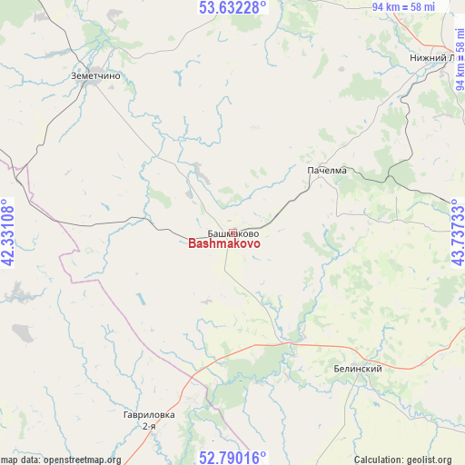
Bashmakovo GPS coordinates[2]
53° 12' 47.844" North, 43° 2' 3.12" East
| Map corner | latitude | longitude |
|---|---|---|
| Upper-left | 53.63228°, | 42.33108° |
| Center: | 53.21329°, | 43.0342° |
| Lower-right: | 52.79016°, | 43.73733° |
| Map W x H: | 93.6×93.6 km | = 58.2×58.2mi |
| max Lat: | 73.50819° ⇑61.3% North |
| Bashmakovo: | 53.21329° |
| min Lat: | ⇓38.7% South 41.28413° |
| min Long | Bashmakovo | max Long |
| -179.12198° | 43.0342° | 179.35046° |
| W 43.3%⇐ | ⇒56.7% E |
Elevation
Elevation of Bashmakovo is 199 m = 653 ft, and this is 3.6 m = 12 ft below average elevation for this country.
| Max E: |
2518 m = 8261 ft | 29.6% |
| Avg. | 202.6 m = 665 ft | |
| Bashmakovo | 199 m = 653 ft | |
Min E: |
-28 m = -92 ft | 70.4% |
See also: Russia elevation on elevation.city.
Geographical zone
Bashmakovo is located in North temperate zone (between Tropic of Cancer and the Arctic Circle). Distance of this North polar circle is 1484.4 km =922.4 mi to North.| Distance of | km | miles | from Bashmakovo |
|---|---|---|---|
| North Pole | 4090.3 | 2541.6 | to North |
| Arctic Circle | 1484.4 | 922.4 | to North |
| Tropic Cancer | 3310.8 | 2057.2 | to South |
| Equator | 5916.8 | 3676.5 | to South |


Nearby cities:
15 places around Bashmakovo: (largest is in red/bold)
• Belinskiy
37.6 km =23.4 mi,  137°
137°
• Bol’shaya Izhmora
40.2 km =25 mi,  340°
340°
• Gavrilovka Vtoraya
41.5 km =25.8 mi,  205°
205°
• Kirsanov
65.5 km =40.7 mi,  198°
198°
• Klyuchi
43.7 km =27.2 mi,  348°
348°
• Lermontovo
48.5 km =30.1 mi,  120°
120°
• Nizhniy Lomov
55.3 km =34.4 mi,  50°
50°
• Pachelma
21.4 km =13.3 mi,  80°
80°
• Pichayevo
55.4 km =34.4 mi,  272°
272°
• Poim
23.2 km =14.4 mi,  153°
153°
• Rakhmanovka
41.2 km =25.6 mi,  356°
356°
• Vadinsk
53.2 km =33.1 mi,  1°
1°
• Verkhniy Lomov
44.5 km =27.7 mi, 50°
• Vyazëmka
49.6 km =30.8 mi,  331°
331°
• Zemetchino
42 km =26.1 mi,  318°
318°
Sources, notices
• [Note1] Compared only with cities in Russia existing in our database
• [Src1] Map data: © OpenStreetMap contributors (CC-BY-SA)
• [Src2] Other city data from geonames.org with taken over terms of usage.
• [Src3] Geographical zone / Annual Mean Temperature by Robert A. Rohde @ Wikipedia
