Pavlovskiy Posad geodata
Pavlovskiy Posad (Moscow Oblast) is a populated place; located in Russia in Europe/Moscow (GMT+3) time zone. With population of 60,051 people, there are 352 cities with bigger population in this country. Compared to other cities in Russia, 63.3% of cities are located further ↓South; 73.8% of cities are located further →East and 57.3% of cities have higher elevation than Pavlovskiy Posad. Note1


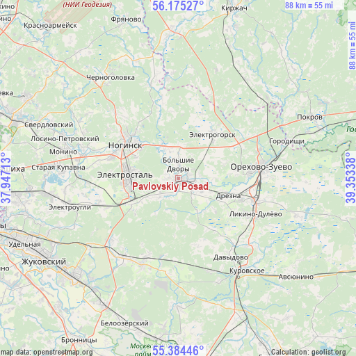
Pavlovskiy Posad GPS coordinates[2]
55° 46' 54.732" North, 38° 39' 0.9" East
| Map corner | latitude | longitude |
|---|---|---|
| Upper-left | 56.17527°, | 37.94713° |
| Center: | 55.78187°, | 38.65025° |
| Lower-right: | 55.38446°, | 39.35338° |
| Map W x H: | 87.9×87.9 km | = 54.6×54.6mi |
| max Lat: | 73.50819° ⇑36.7% North |
| Pavlovskiy Posad: | 55.78187° |
| min Lat: | ⇓63.3% South 41.28413° |
| min Long | Pavlovskiy Posa | max Long |
| -179.12198° | 38.65025° | 179.35046° |
| W 26.2%⇐ | ⇒73.8% E |
Elevation
Elevation of Pavlovskiy Posad is 130 m = 427 ft, and this is 72.6 m = 238 ft below average elevation for this country.
| Max E: |
2518 m = 8261 ft | 57.3% |
| Avg. | 202.6 m = 665 ft | |
| Pavlovskiy Posad | 130 m = 427 ft | |
Min E: |
-28 m = -92 ft | 42.7% |
See also: Pavlovskiy Posad elevation on elevation.city.
Geographical zone
Pavlovskiy Posad is located in North temperate zone (between Tropic of Cancer and the Arctic Circle). Distance of this North polar circle is 1198.8 km =744.9 mi to North.| Distance of | km | miles | from Pavlovskiy Posad |
|---|---|---|---|
| North Pole | 3804.7 | 2364.1 | to North |
| Arctic Circle | 1198.8 | 744.9 | to North |
| Tropic Cancer | 3596.4 | 2234.7 | to South |
| Equator | 6202.4 | 3854 | to South |


Nearby cities:
15 places around Pavlovskiy Posad: (largest is in red/bold)
• Davydovo
23.4 km =14.5 mi,  145°
145°
• Demikhovo
14.7 km =9.1 mi,  83°
83°
• Drezna
13.1 km =8.1 mi,  109°
109°
• Elektrogorsk
14.2 km =8.8 mi,  36°
36°
• Elektrostal’
12.8 km =8 mi,  273°
273°
• Fryazevo
12.8 km =8 mi,  245°
245°
• Imeni Vorovskogo
21.2 km =13.2 mi, 254°
• Kabanovo
18.2 km =11.3 mi,  101°
101°
• Likino-Dulevo
20.7 km =12.9 mi, 113°
• Malaya Dubna
21.8 km =13.5 mi,  60°
60°
• Noginsk
16 km =9.9 mi,  306°
306°
• Novokharitonovo
22.4 km =13.9 mi,  202°
202°
• Orekhovo-Zuyevo
19.7 km =12.2 mi, 81°
• Rakhmanovo
4.9 km =3 mi,  210°
210°
• Yamkino
21.8 km =13.5 mi,  315°
315°
Sources, notices
• [Note1] Compared only with cities in Russia existing in our database
• [Src1] Map data: © OpenStreetMap contributors (CC-BY-SA)
• [Src2] Other city data from geonames.org with taken over terms of usage.
• [Src3] Geographical zone / Annual Mean Temperature by Robert A. Rohde @ Wikipedia
