Elektrostal’ geodata
Elektrostal’ (Moscow Oblast) is a populated place; located in Russia in Europe/Moscow (GMT+3) time zone. With population of 144,387 people, there are 133 cities with bigger population in this country. Compared to other cities in Russia, 63.4% of cities are located further ↓South; 74.7% of cities are located further →East and 55.3% of cities have lower elevation than Elektrostal’. Note1


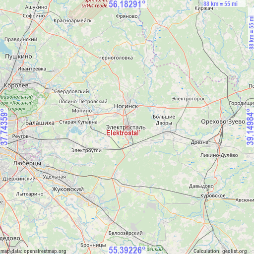
Elektrostal’ GPS coordinates[2]
55° 47' 22.524" North, 38° 26' 48.156" East
| Map corner | latitude | longitude |
|---|---|---|
| Upper-left | 56.18291°, | 37.74359° |
| Center: | 55.78959°, | 38.44671° |
| Lower-right: | 55.39226°, | 39.14984° |
| Map W x H: | 87.9×87.9 km | = 54.6×54.6mi |
| max Lat: | 73.50819° ⇑36.6% North |
| Elektrostal’: | 55.78959° |
| min Lat: | ⇓63.4% South 41.28413° |
| min Long | Elektrostal’ | max Long |
| -179.12198° | 38.44671° | 179.35046° |
| W 25.3%⇐ | ⇒74.7% E |
Elevation
Elevation of Elektrostal’ is 157 m = 515 ft, and this is 45.6 m = 150 ft below average elevation for this country.
| Max E: |
2518 m = 8261 ft | 44.7% |
| Avg. | 202.6 m = 665 ft | |
| Elektrostal’ | 157 m = 515 ft | |
Min E: |
-28 m = -92 ft | 55.3% |
See also: Elektrostal’ elevation on elevation.city.
Geographical zone
Elektrostal’ is located in North temperate zone (between Tropic of Cancer and the Arctic Circle). Distance of this North polar circle is 1198 km =744.4 mi to North.| Distance of | km | miles | from Elektrostal’ |
|---|---|---|---|
| North Pole | 3803.8 | 2363.6 | to North |
| Arctic Circle | 1198 | 744.4 | to North |
| Tropic Cancer | 3597.3 | 2235.3 | to South |
| Equator | 6203.2 | 3854.5 | to South |


Nearby cities:
15 places around Elektrostal’: (largest is in red/bold)
• Elektrougli
16.5 km =10.3 mi,  244°
244°
• Fryazevo
6.4 km =4 mi,  169°
169°
• Gzhel’
20.2 km =12.6 mi,  189°
189°
• Imeni Vorovskogo
10 km =6.2 mi,  230°
230°
• Kupavna
20.3 km =12.6 mi,  256°
256°
• Losino-Petrovskiy
17.8 km =11.1 mi,  300°
300°
• Monino
16.9 km =10.5 mi,  290°
290°
• Noginsk
8.6 km =5.3 mi,  358°
358°
• Obukhovo
11.9 km =7.4 mi, 293°
• Pavlovskiy Posad
12.8 km =8 mi,  93°
93°
• Rakhmanovo
11.5 km =7.1 mi,  116°
116°
• Rybkhoz
19.5 km =12.1 mi,  269°
269°
• Staraya Kupavna
16.8 km =10.4 mi,  277°
277°
• Vishnyakovskiye Dachi
19.8 km =12.3 mi, 261°
• Yamkino
14.8 km =9.2 mi,  349°
349°
Sources, notices
• [Note1] Compared only with cities in Russia existing in our database
• [Src1] Map data: © OpenStreetMap contributors (CC-BY-SA)
• [Src2] Other city data from geonames.org with taken over terms of usage.
• [Src3] Geographical zone / Annual Mean Temperature by Robert A. Rohde @ Wikipedia
