Ol’gino geodata
Ol’gino (Leningradskaya Oblast') is a populated place; located in Russia in Europe/Moscow (GMT+3) time zone. With population of 7,600 people, there are 1884 cities with bigger population in this country. Compared to other cities in Russia, 89.2% of cities are located further ↓South; 97.2% of cities are located further →East and 90.1% of cities have higher elevation than Ol’gino. Note1


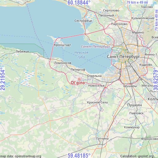
Ol’gino GPS coordinates[2]
59° 50' 13.272" North, 29° 55' 21.576" East
| Map corner | latitude | longitude |
|---|---|---|
| Upper-left | 60.18844°, | 29.21954° |
| Center: | 59.83702°, | 29.92266° |
| Lower-right: | 59.48185°, | 30.62579° |
| Map W x H: | 78.6×78.6 km | = 48.8×48.8mi |
| max Lat: | 73.50819° ⇑10.8% North |
| Ol’gino: | 59.83702° |
| min Lat: | ⇓89.2% South 41.28413° |
| min Long | Ol’gino | max Long |
| -179.12198° | 29.92266° | 179.35046° |
| W 2.8%⇐ | ⇒97.2% E |
Elevation
Elevation of Ol’gino is 28 m = 92 ft, and this is 174.6 m = 573 ft below average elevation for this country.
| Max E: |
2518 m = 8261 ft | 90.1% |
| Avg. | 202.6 m = 665 ft | |
| Ol’gino | 28 m = 92 ft | |
Min E: |
-28 m = -92 ft | 9.9% |
See also: Russia elevation on elevation.city.
Geographical zone
Ol’gino is located in North temperate zone (between Tropic of Cancer and the Arctic Circle). Distance of this North polar circle is 747.9 km =464.7 mi to North.| Distance of | km | miles | from Ol’gino |
|---|---|---|---|
| North Pole | 3353.8 | 2084 | to North |
| Arctic Circle | 747.9 | 464.7 | to North |
| Tropic Cancer | 4047.3 | 2514.9 | to South |
| Equator | 6653.3 | 4134.2 | to South |


Nearby cities:
15 places around Ol’gino: (largest is in red/bold)
• Annino
10.5 km =6.5 mi,  134°
134°
• Avtovo
19.5 km =12.1 mi,  78°
78°
• Dachnoye
18.6 km =11.6 mi,  88°
88°
• Gorbunki
4.4 km =2.7 mi, 127°
• Gorelovo
13.9 km =8.6 mi,  121°
121°
• Gostilitsy
19.5 km =12.1 mi,  239°
239°
• Kipen’
18.6 km =11.6 mi,  192°
192°
• Krasnoye Selo
14.4 km =8.9 mi,  139°
139°
• Lomonosov
11.4 km =7.1 mi,  312°
312°
• Peterhof
5.3 km =3.3 mi,  346°
346°
• Petrodvorets
9.4 km =5.8 mi, 313°
• Russko-Vysotskoye
15.3 km =9.5 mi,  175°
175°
• Sosnovaya Polyana
12.5 km =7.8 mi, 90°
• Strel'na
6.5 km =4 mi, 75°
• Uritsk
14.1 km =8.8 mi, 89°
Sources, notices
• [Note1] Compared only with cities in Russia existing in our database
• [Src1] Map data: © OpenStreetMap contributors (CC-BY-SA)
• [Src2] Other city data from geonames.org with taken over terms of usage.
• [Src3] Geographical zone / Annual Mean Temperature by Robert A. Rohde @ Wikipedia
