Peterhof geodata
Peterhof (St.-Petersburg) is a populated place; located in Russia in Europe/Moscow (GMT+3) time zone. With population of 73,199 people, there are 275 cities with bigger population in this country. Compared to other cities in Russia, 89.5% of cities are located further ↓South; 97.3% of cities are located further →East and 90.7% of cities have higher elevation than Peterhof. Note1


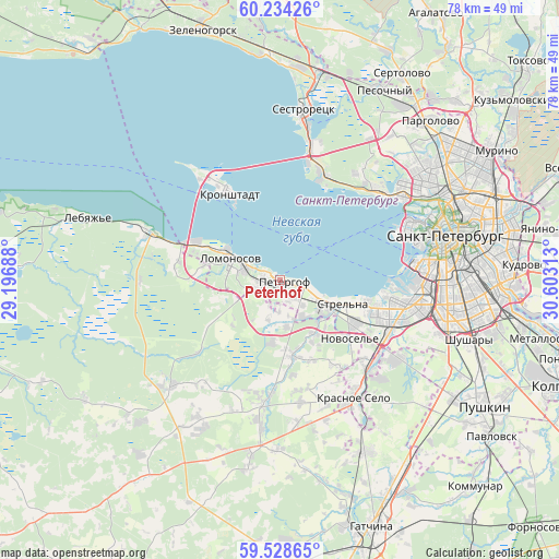
Peterhof GPS coordinates[2]
59° 52' 59.988" North, 29° 54' 0" East
| Map corner | latitude | longitude |
|---|---|---|
| Upper-left | 60.23426°, | 29.19688° |
| Center: | 59.88333°, | 29.9° |
| Lower-right: | 59.52865°, | 30.60313° |
| Map W x H: | 78.5×78.5 km | = 48.8×48.8mi |
| max Lat: | 73.50819° ⇑10.5% North |
| Peterhof: | 59.88333° |
| min Lat: | ⇓89.5% South 41.28413° |
| min Long | Peterhof | max Long |
| -179.12198° | 29.9° | 179.35046° |
| W 2.7%⇐ | ⇒97.3% E |
Elevation
Elevation of Peterhof is 26 m = 85 ft, and this is 176.6 m = 579 ft below average elevation for this country.
| Max E: |
2518 m = 8261 ft | 90.7% |
| Avg. | 202.6 m = 665 ft | |
| Peterhof | 26 m = 85 ft | |
Min E: |
-28 m = -92 ft | 9.3% |
See also: Peterhof elevation on elevation.city.
Geographical zone
Peterhof is located in North temperate zone (between Tropic of Cancer and the Arctic Circle). Distance of this North polar circle is 742.8 km =461.6 mi to North.| Distance of | km | miles | from Peterhof |
|---|---|---|---|
| North Pole | 3348.7 | 2080.8 | to North |
| Arctic Circle | 742.8 | 461.6 | to North |
| Tropic Cancer | 4052.5 | 2518.1 | to South |
| Equator | 6658.4 | 4137.3 | to South |


Nearby cities:
15 places around Peterhof: (largest is in red/bold)
• Annino
15.3 km =9.5 mi,  145°
145°
• Bol’shaya Izhora
19 km =11.8 mi,  288°
288°
• Gorbunki
9.1 km =5.7 mi, 148°
• Gorelovo
18 km =11.2 mi,  133°
133°
• Gorskaya
18.6 km =11.6 mi,  12°
12°
• Kronshtadt
14.5 km =9 mi,  329°
329°
• Lakhtinskiy
18.6 km =11.6 mi,  47°
47°
• Lisiy Nos
16.3 km =10.1 mi,  24°
24°
• Lomonosov
7.5 km =4.7 mi, 289°
• Ol’gino
5.3 km =3.3 mi,  166°
166°
• Ol’gino
18.4 km =11.4 mi,  40°
40°
• Petrodvorets
5.7 km =3.5 mi,  283°
283°
• Sosnovaya Polyana
14.8 km =9.2 mi,  111°
111°
• Strel'na
8.4 km =5.2 mi, 114°
• Uritsk
16.1 km =10 mi, 107°
Sources, notices
• [Note1] Compared only with cities in Russia existing in our database
• [Src1] Map data: © OpenStreetMap contributors (CC-BY-SA)
• [Src2] Other city data from geonames.org with taken over terms of usage.
• [Src3] Geographical zone / Annual Mean Temperature by Robert A. Rohde @ Wikipedia
