Oyskhara geodata
Oyskhara (Chechnya) is a populated place; located in Russia in Europe/Moscow (GMT+3) time zone. With population of 12,795 people, there are 1219 cities with bigger population in this country. Compared to other cities in Russia, 95.7% of cities are located further ↑North; 53.4% of cities are located further ←West and 60.6% of cities have higher elevation than Oyskhara. Note1


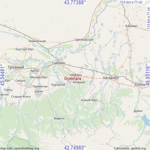
Oyskhara GPS coordinates[2]
43° 15' 50.472" North, 46° 14' 52.908" East
| Map corner | latitude | longitude |
|---|---|---|
| Upper-left | 43.77388°, | 45.54491° |
| Center: | 43.26402°, | 46.24803° |
| Lower-right: | 42.74985°, | 46.95116° |
| Map W x H: | 113.9×113.9 km | = 70.8×70.8mi |
| max Lat: | 73.50819° ⇑95.7% North |
| Oyskhara: | 43.26402° |
| min Lat: | ⇓4.3% South 41.28413° |
| min Long | Oyskhara | max Long |
| -179.12198° | 46.24803° | 179.35046° |
| W 53.4%⇐ | ⇒46.6% E |
Elevation
Elevation of Oyskhara is 123 m = 404 ft, and this is 79.6 m = 261 ft below average elevation for this country.
| Max E: |
2518 m = 8261 ft | 60.6% |
| Avg. | 202.6 m = 665 ft | |
| Oyskhara | 123 m = 404 ft | |
Min E: |
-28 m = -92 ft | 39.4% |
See also: Russia elevation on elevation.city.
Geographical zone
Oyskhara is located in North temperate zone (between Tropic of Cancer and the Arctic Circle). Distance of this Northern Tropic circle is 2204.6 km =1369.9 mi to South.| Distance of | km | miles | from Oyskhara |
|---|---|---|---|
| North Pole | 5196.6 | 3229 | to North |
| Arctic Circle | 2590.7 | 1609.8 | to North |
| Tropic Cancer | 2204.6 | 1369.9 | to South |
| Equator | 4810.5 | 2989.1 | to South |


Nearby cities:
15 places around Oyskhara: (largest is in red/bold)
• Aksay
20 km =12.4 mi,  52°
52°
• Alleroy
5.9 km =3.7 mi,  152°
152°
• Bachi-Yurt
6.2 km =3.9 mi,  224°
224°
• Botashyurt
21.8 km =13.5 mi,  77°
77°
• Engel’-Yurt
11.4 km =7.1 mi, 52°
• Gerzel’-Aul
12.6 km =7.8 mi,  98°
98°
• Gudermes
14.8 km =9.2 mi,  310°
310°
• Ilaskhan-Yurt
11.9 km =7.4 mi,  278°
278°
• Ishkhoy-Yurt
12.8 km =8 mi,  116°
116°
• Kurchaloy
14.7 km =9.1 mi,  241°
241°
• Mayrtup
11.6 km =7.2 mi,  234°
234°
• Nuradilovo
17.1 km =10.6 mi, 82°
• Solnechnoye
21 km =13 mi,  86°
86°
• Tsotsin-Yurt
20.2 km =12.6 mi,  263°
263°
• Yalkhoy-Mokhk
18.3 km =11.4 mi,  194°
194°
Sources, notices
• [Note1] Compared only with cities in Russia existing in our database
• [Src1] Map data: © OpenStreetMap contributors (CC-BY-SA)
• [Src2] Other city data from geonames.org with taken over terms of usage.
• [Src3] Geographical zone / Annual Mean Temperature by Robert A. Rohde @ Wikipedia
