Gerzel’-Aul geodata
Gerzel’-Aul (Chechnya) is a populated place; located in Russia in Europe/Moscow (GMT+3) time zone. With population of 3,527 people, there are 3383 cities with bigger population in this country. Compared to other cities in Russia, 95.9% of cities are located further ↑North; 53.9% of cities are located further ←West and 51.9% of cities have lower elevation than Gerzel’-Aul. Note1


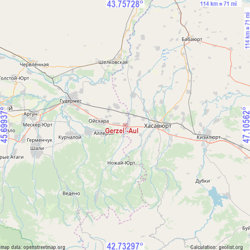
Gerzel’-Aul GPS coordinates[2]
43° 14' 50.208" North, 46° 24' 8.964" East
| Map corner | latitude | longitude |
|---|---|---|
| Upper-left | 43.75728°, | 45.69937° |
| Center: | 43.24728°, | 46.40249° |
| Lower-right: | 42.73297°, | 47.10562° |
| Map W x H: | 113.9×113.9 km | = 70.8×70.8mi |
| max Lat: | 73.50819° ⇑95.9% North |
| Gerzel’-Aul: | 43.24728° |
| min Lat: | ⇓4.1% South 41.28413° |
| min Long | Gerzel’-Aul | max Long |
| -179.12198° | 46.40249° | 179.35046° |
| W 53.9%⇐ | ⇒46.1% E |
Elevation
Elevation of Gerzel’-Aul is 149 m = 489 ft, and this is 53.6 m = 176 ft below average elevation for this country.
| Max E: |
2518 m = 8261 ft | 48.1% |
| Avg. | 202.6 m = 665 ft | |
| Gerzel’-Aul | 149 m = 489 ft | |
Min E: |
-28 m = -92 ft | 51.9% |
See also: Russia elevation on elevation.city.
Geographical zone
Gerzel’-Aul is located in North temperate zone (between Tropic of Cancer and the Arctic Circle). Distance of this Northern Tropic circle is 2202.7 km =1368.7 mi to South.| Distance of | km | miles | from Gerzel’-Aul |
|---|---|---|---|
| North Pole | 5198.4 | 3230.1 | to North |
| Arctic Circle | 2592.5 | 1610.9 | to North |
| Tropic Cancer | 2202.7 | 1368.7 | to South |
| Equator | 4808.6 | 2987.9 | to South |


Nearby cities:
15 places around Gerzel’-Aul: (largest is in red/bold)
• Aksay
14.3 km =8.9 mi,  13°
13°
• Alleroy
10.3 km =6.4 mi,  251°
251°
• Bachi-Yurt
17.1 km =10.6 mi,  261°
261°
• Bammatyurt
19.9 km =12.4 mi,  56°
56°
• Botashyurt
11 km =6.8 mi,  52°
52°
• Engel’-Yurt
9.4 km =5.8 mi,  338°
338°
• Ishkhoy-Yurt
4 km =2.5 mi,  195°
195°
• Khasavyurt
15 km =9.3 mi,  88°
88°
• Novolakskoye
15.6 km =9.7 mi,  155°
155°
• Nozhay-Yurt
17.3 km =10.7 mi,  186°
186°
• Nuradilovo
6.1 km =3.8 mi, 47°
• Oyskhara
12.6 km =7.8 mi,  278°
278°
• Pokrovskoye
21.8 km =13.5 mi,  77°
77°
• Solnechnoye
9 km =5.6 mi,  69°
69°
• Zandak
21.6 km =13.4 mi,  168°
168°
Sources, notices
• [Note1] Compared only with cities in Russia existing in our database
• [Src1] Map data: © OpenStreetMap contributors (CC-BY-SA)
• [Src2] Other city data from geonames.org with taken over terms of usage.
• [Src3] Geographical zone / Annual Mean Temperature by Robert A. Rohde @ Wikipedia
